IMAGES TAKEN NEAR TO
The Staithes, SHIPLEY, BD17 6DB
Introduction
This page details the photographs taken nearby to The Staithes, BD17 6DB by members of the Geograph project.
The Geograph project started in 2005 with the aim of publishing, organising and preserving representative images for every square kilometre of Great Britain, Ireland and the Isle of Man.

There are currently over 7.5m images from over14,400 individuals and you can help contribute to the project by visiting https://www.geograph.org.uk
Image Map
Images are licensed for reuse under creativecommons.org/licenses/by-sa/2.0
Notes
- Clicking on the map will re-center to the selected point.
- The higher the marker number, the further away the image location is from the centre of the postcode.
Image Listing (146 Images Found)
Images are licensed for reuse under creativecommons.org/licenses/by-sa/2.0
Image
Details
Distance
1
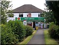
corner house Sandwich Shop - Cliffe Avenue
Image: © Betty Longbottom
Taken: 23 Nov 2009
0.00 miles
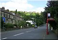
2
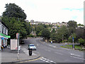
Baildon Road (BN6151) seen from the end of Cliffe Avenue, Baildon
Image: © habiloid
Taken: 13 Jul 2008
0.00 miles
3
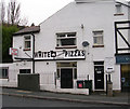
White House Pizzas - Cliffe Avenue
Image: © Betty Longbottom
Taken: 23 Nov 2009
0.01 miles
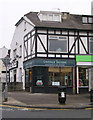
4
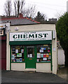
Cliffe Avenue Chemist - Cliffe Avenue
Image: © Betty Longbottom
Taken: 23 Nov 2009
0.02 miles
9
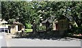
War Memorial - Browgate
The inscription panels are situated within the two small shelters at each side.
Image: © Betty Longbottom
Taken: 31 Jul 2007
0.04 miles