IMAGES TAKEN NEAR TO
Enfield Road, SHIPLEY, BD17 5QE
Introduction
This page details the photographs taken nearby to Enfield Road, BD17 5QE by members of the Geograph project.
The Geograph project started in 2005 with the aim of publishing, organising and preserving representative images for every square kilometre of Great Britain, Ireland and the Isle of Man.

There are currently over 7.5m images from over14,400 individuals and you can help contribute to the project by visiting https://www.geograph.org.uk
Image Map
Images are licensed for reuse under creativecommons.org/licenses/by-sa/2.0
Notes
- Clicking on the map will re-center to the selected point.
- The higher the marker number, the further away the image location is from the centre of the postcode.
Image Listing (55 Images Found)
Images are licensed for reuse under creativecommons.org/licenses/by-sa/2.0
Image
Details
Distance
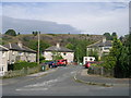
4
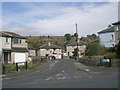
Cliffe Avenue - viewed from Cliffe Lane West
Image: © Betty Longbottom
Taken: 2 Sep 2011
0.04 miles
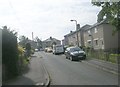
6
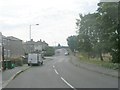
Cliffe Lane West - viewed from Cliffe Avenue
Image: © Betty Longbottom
Taken: 2 Sep 2011
0.05 miles
7
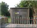
Electricity Substation No 4540 - Temple Rhydding Drive
Image: © Betty Longbottom
Taken: 2 Sep 2011
0.05 miles
8
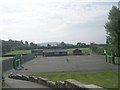
Sports Ground - viewed from Temple Rhydding Drive
Image: © Betty Longbottom
Taken: 2 Sep 2011
0.05 miles
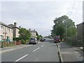
9
Green Road - viewed from Cliffe Lane West
Image: © Betty Longbottom
Taken: 2 Sep 2011
0.05 miles
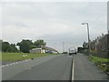
10
Green Road - viewed from Cliffe Lane West
Image: © Betty Longbottom
Taken: 2 Sep 2011
0.05 miles