IMAGES TAKEN NEAR TO
The Laurels, Fernbank Drive, BINGLEY, BD16 4TL
Introduction
This page details the photographs taken nearby to The Laurels, Fernbank Drive, BD16 4TL by members of the Geograph project.
The Geograph project started in 2005 with the aim of publishing, organising and preserving representative images for every square kilometre of Great Britain, Ireland and the Isle of Man.

There are currently over 7.5m images from over14,400 individuals and you can help contribute to the project by visiting https://www.geograph.org.uk
Image Map
Images are licensed for reuse under creativecommons.org/licenses/by-sa/2.0
Notes
- Clicking on the map will re-center to the selected point.
- The higher the marker number, the further away the image location is from the centre of the postcode.
Image Listing (135 Images Found)
Images are licensed for reuse under creativecommons.org/licenses/by-sa/2.0
Image
Details
Distance
2
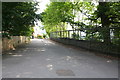
St Joseph's Catholic Primary School - Crow Nest Road
Image: © Betty Longbottom
Taken: 10 Oct 2007
0.04 miles
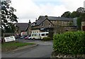
5
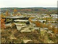
Gilstead Crag
A gritstone outcrop on the east side of the Aire Valley.
Image: © Stephen Craven
Taken: 16 Nov 2021
0.08 miles
6
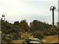
Transmitter masts on Gilstead Crag
The crag commands a wide view over the Aire Valley so is a suitable site for this sort of facility.
Image: © Stephen Craven
Taken: 16 Nov 2021
0.09 miles
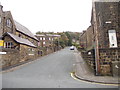
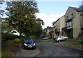
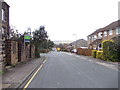
8
Crownest Road - viewed from Nethermoor View
Image: © Betty Longbottom
Taken: 29 Sep 2012
0.09 miles
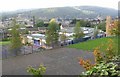
9
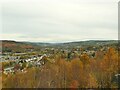
View north-west from Gilstead Crag
In the foreground is the wooded hillside below Gilstead Edge, and beyond a view up the Aire Valley towards Keighley.
Image: © Stephen Craven
Taken: 16 Nov 2021
0.09 miles
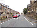
10
Crownest Road - viewed from Nethermoor View
Image: © Betty Longbottom
Taken: 29 Sep 2012
0.09 miles