IMAGES TAKEN NEAR TO
Jardine Road, BINGLEY, BD16 4NU
Introduction
This page details the photographs taken nearby to Jardine Road, BD16 4NU by members of the Geograph project.
The Geograph project started in 2005 with the aim of publishing, organising and preserving representative images for every square kilometre of Great Britain, Ireland and the Isle of Man.

There are currently over 7.5m images from over14,400 individuals and you can help contribute to the project by visiting https://www.geograph.org.uk
Image Map
Images are licensed for reuse under creativecommons.org/licenses/by-sa/2.0
Notes
- Clicking on the map will re-center to the selected point.
- The higher the marker number, the further away the image location is from the centre of the postcode.
Image Listing (349 Images Found)
Images are licensed for reuse under creativecommons.org/licenses/by-sa/2.0
Image
Details
Distance
4
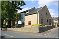
Bingley Methodist Church
Bingley Methodist Church was known as Mornington Road Methodist Church until the mid 1990's.
The foundation stone for the former Church building was laid on 4 November 1871, and the official opening was on 23 September 1874.
However, the large building was proving to be very expensive to maintain so the decision was taken to demolish it and build a new church. The plans for the new Church building were finally approved by Bradford Council's planners on 19 July 2001.
Demolition of the building commenced in March 2002 and the site had been levelled by the following June. During demolition and construction, the congregation of Bingley Methodist Church worshipped next door at Priestthorpe Primary School Image
Construction of the new church building took place from July 2002 to March 2003 and the first service in the new church took place on Sunday 16 March 2003.
The spire of the original church was an Ordnance Survey intersected station trig point, http://www.trigpointing.uk/trig/12832 : its top is preserved in the new church's grounds and can be seen to the left of the church name notice board.
Image: © Roger Templeman
Taken: 8 Aug 2015
0.03 miles
9
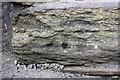
Weathered benchmark on Priestthorpe Primary School
Ordnance Survey cut mark benchmark described on the Bench Mark Database at http://www.bench-marks.org.uk/bm72572
Image: © Roger Templeman
Taken: 8 Aug 2015
0.05 miles
10
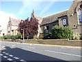
Priestthorpe Primary School - Mornington Road
Image: © Betty Longbottom
Taken: 29 Sep 2012
0.05 miles