IMAGES TAKEN NEAR TO
Westleigh, BINGLEY, BD16 4LX
Introduction
This page details the photographs taken nearby to Westleigh, BD16 4LX by members of the Geograph project.
The Geograph project started in 2005 with the aim of publishing, organising and preserving representative images for every square kilometre of Great Britain, Ireland and the Isle of Man.

There are currently over 7.5m images from over14,400 individuals and you can help contribute to the project by visiting https://www.geograph.org.uk
Image Map (Loading...)


Getting Data...Please wait
Leaflet Map data © OpenStreetMap
Images are licensed for reuse under creativecommons.org/licenses/by-sa/2.0
Notes
- Clicking on the map will re-center to the selected point.
- The higher the marker number, the further away the image location is from the centre of the postcode.
Image Listing (241 Images Found)
Images are licensed for reuse under creativecommons.org/licenses/by-sa/2.0
Image
Details
Distance
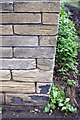
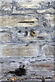
2
Benchmark on wall at entrance to #89 Park Road
Ordnance Survey cut mark benchmark described on the Bench Mark Database at http://www.bench-marks.org.uk/bm43888
Image: © Roger Templeman
Taken: 9 Jul 2012
0.07 miles
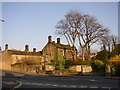
3
#89 Park Road
There is an OS benchmark Image on the end of the wall at the left hand side of the gateway entrance to the house
Image: © Roger Templeman
Taken: 9 Jul 2012
0.07 miles
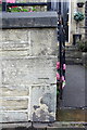
5
Benchmark on boundary wall angle of #19 Priestthorpe Road
Ordnance Survey cut mark benchmark described on the Bench Mark Database at http://www.bench-marks.org.uk/bm43986
Image: © Roger Templeman
Taken: 9 Jul 2012
0.08 miles
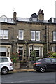
6
#19 Priestthorpe Road
There is an OS benchmark Image on the angle of the wall at the entrance to the side track
Image: © Roger Templeman
Taken: 9 Jul 2012
0.08 miles
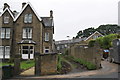
7
NHS Care Home, Park Road, Bingley
Converted from a house and cottages.
Image: © Humphrey Bolton
Taken: 1 Apr 2007
0.08 miles
8
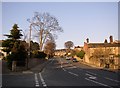
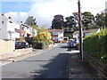
Park Road, Bingley
The gradient steepens above Hall Bank Drive.
Image: © Humphrey Bolton
Taken: 1 Apr 2007
0.08 miles
9
Benchmark on the wall of Park Road
Ordnance Survey cut mark benchmark described on the Bench Mark Database at http://www.bench-marks.org.uk/bm43889
Image: © Roger Templeman
Taken: 9 Jul 2012
0.09 miles
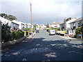
10
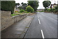
Park Road southwest of Claremont Gardens junction
There is an OS benchmark Image on the wall at the left hand side of the image
Image: © Roger Templeman
Taken: 9 Jul 2012
0.10 miles