IMAGES TAKEN NEAR TO
The Orchards, BINGLEY, BD16 4AZ
Introduction
This page details the photographs taken nearby to The Orchards, BD16 4AZ by members of the Geograph project.
The Geograph project started in 2005 with the aim of publishing, organising and preserving representative images for every square kilometre of Great Britain, Ireland and the Isle of Man.

There are currently over 7.5m images from over14,400 individuals and you can help contribute to the project by visiting https://www.geograph.org.uk
Image Map
Images are licensed for reuse under creativecommons.org/licenses/by-sa/2.0
Notes
- Clicking on the map will re-center to the selected point.
- The higher the marker number, the further away the image location is from the centre of the postcode.
Image Listing (59 Images Found)
Images are licensed for reuse under creativecommons.org/licenses/by-sa/2.0
Image
Details
Distance
1
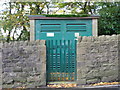
Electricity Substation No 1912 - Lady Lane
Image: © Betty Longbottom
Taken: 26 Oct 2012
0.07 miles
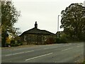
2
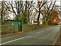
Substation, Lady Lane
The sign beyond advertises the Oakwood Hall Hotel, which is down the hill beyond the wall.
Image: © Stephen Craven
Taken: 16 Nov 2021
0.07 miles
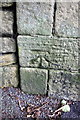
3

Benchmark on Lady Lane Park School Nursery
Ordnance Survey cut mark benchmark described on the Bench Mark Database at http://www.bench-marks.org.uk/bm44232
Image: © Roger Templeman
Taken: 27 Jul 2012
0.08 miles

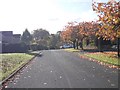
5
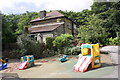
Park Nursery School, Lady Lane
There is an OS benchmark Image on the back of the school (Lady Lane face)
Image: © Roger Templeman
Taken: 27 Jul 2012
0.08 miles
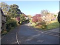
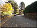
8
Greenhill Lodge, Lady Lane
Once the outer lodge of Greenhill Hall (there was also an inner one). The hall, listed grade II, still exists but accessed from the north. The inner lodge and most of the avenue between them are now gone.
Image: © Stephen Craven
Taken: 16 Nov 2021
0.10 miles
10
Benchmark on Lady Lane wall at entrance to woodland
Ordnance Survey cut mark benchmark described on the Bench Mark Database at http://www.bench-marks.org.uk/bm37516
Image: © Roger Templeman
Taken: 27 Jul 2012
0.10 miles