IMAGES TAKEN NEAR TO
Parklands, BINGLEY, BD16 3PD
Introduction
This page details the photographs taken nearby to Parklands, BD16 3PD by members of the Geograph project.
The Geograph project started in 2005 with the aim of publishing, organising and preserving representative images for every square kilometre of Great Britain, Ireland and the Isle of Man.

There are currently over 7.5m images from over14,400 individuals and you can help contribute to the project by visiting https://www.geograph.org.uk
Image Map
Images are licensed for reuse under creativecommons.org/licenses/by-sa/2.0
Notes
- Clicking on the map will re-center to the selected point.
- The higher the marker number, the further away the image location is from the centre of the postcode.
Image Listing (85 Images Found)
Images are licensed for reuse under creativecommons.org/licenses/by-sa/2.0
Image
Details
Distance
1
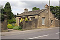
'Moor Edge Cottage', Warren Lane
There is an OS benchmark Image at pavement level on the near corner of the house
Image: © Roger Templeman
Taken: 27 Jul 2012
0.02 miles
3
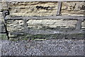
Benchmark on Moor Edge Cottage, Warren Lane
Ordnance Survey cut mark benchmark described on the Bench Mark Database at http://www.bench-marks.org.uk/bm44443
Image: © Roger Templeman
Taken: 27 Jul 2012
0.03 miles
7
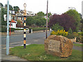
Stone and signpost, Otley Road, Eldwick
The carving on the stone reads 'Eldwick Village Society Millennium Stone AD 2003'. The old Bingley UDC signpost points to Bingley and Morton (left), Baildon, Otley and Gilstead (right)
Image: © David Spencer
Taken: 31 Jul 2005
0.06 miles
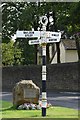
8

Direction Sign ? Signpost
Located on the southeast side of the junction of Otley Road, Park Road, Warren Lane and Heights Lane in Bingley parish. 4 arms and annulus finial. See also https://www.geograph.org.uk/photo/32176 and https://www.geograph.org.uk/photo/6229450.
Milestone Society National ID: YW_SE1140
Image: © W Biswas
Taken: Unknown
0.06 miles
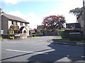
9
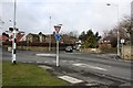
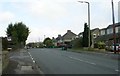
Otley Road Roundabout
The mini-roundabout lies just outside the Eldwick boundary. Warren Lane joins from the left and Heights Lane from the right.
Image: © Richard Kay
Taken: 12 Mar 2009
0.07 miles