IMAGES TAKEN NEAR TO
Gilstead Lane, BINGLEY, BD16 3NP
Introduction
This page details the photographs taken nearby to Gilstead Lane, BD16 3NP by members of the Geograph project.
The Geograph project started in 2005 with the aim of publishing, organising and preserving representative images for every square kilometre of Great Britain, Ireland and the Isle of Man.

There are currently over 7.5m images from over14,400 individuals and you can help contribute to the project by visiting https://www.geograph.org.uk
Image Map
Images are licensed for reuse under creativecommons.org/licenses/by-sa/2.0
Notes
- Clicking on the map will re-center to the selected point.
- The higher the marker number, the further away the image location is from the centre of the postcode.
Image Listing (95 Images Found)
Images are licensed for reuse under creativecommons.org/licenses/by-sa/2.0
Image
Details
Distance
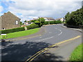
1
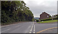
Junction of Pendle Road and Gilstead Lane, Gilstead
Image: © habiloid
Taken: 15 Aug 2020
0.04 miles
2
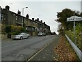
Welcome to Gilstead
A sign on Ferncliffe Road.
Image: © Stephen Craven
Taken: 16 Nov 2021
0.04 miles
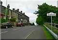
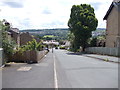
5
Pendle Road in Gilstead
Looking north-westward.
Image: © Peter Wood
Taken: 5 Aug 2017
0.05 miles
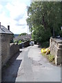
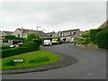
9
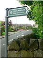
Primrose Lane and footpath sign, Gilstead
Looking up Primrose Lane, towards Gilstead Lane, at the start of the footpath to Sparable Lane.
Image: © Rich Tea
Taken: 28 May 2009
0.07 miles
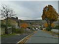
10
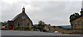
St. Wilfred's Church, Gilstead
St. Wilfred's is at the junction of Gilstead Lane and South Hill Drive.
Image: © habiloid
Taken: 15 Aug 2020
0.07 miles