IMAGES TAKEN NEAR TO
Lyndale Road, BINGLEY, BD16 3HE
Introduction
This page details the photographs taken nearby to Lyndale Road, BD16 3HE by members of the Geograph project.
The Geograph project started in 2005 with the aim of publishing, organising and preserving representative images for every square kilometre of Great Britain, Ireland and the Isle of Man.

There are currently over 7.5m images from over14,400 individuals and you can help contribute to the project by visiting https://www.geograph.org.uk
Image Map (Loading...)


Getting Data...Please wait
Leaflet Map data © OpenStreetMap
Images are licensed for reuse under creativecommons.org/licenses/by-sa/2.0
Notes
- Clicking on the map will re-center to the selected point.
- The higher the marker number, the further away the image location is from the centre of the postcode.
Image Listing (53 Images Found)
Images are licensed for reuse under creativecommons.org/licenses/by-sa/2.0
Image
Details
Distance
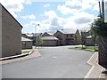
1
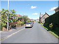
Lyndale Road - looking towards Otley Road
Image: © Betty Longbottom
Taken: 18 Jun 2012
0.04 miles
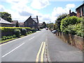
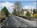
4
Otley Road, Eldwick
St Lawrence's Church is on the left
Image: © Humphrey Bolton
Taken: 1 Apr 2014
0.08 miles
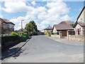
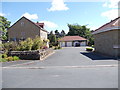
9
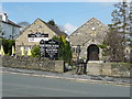
Eldwick Memorial Hall and Birches Free House
Birches was formerly a private club, and is now a community pub. It has a connecting door to the adjoining Memorial Hall.
Image: © Humphrey Bolton
Taken: 1 Apr 2014
0.10 miles
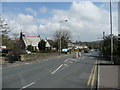
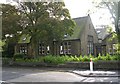
10
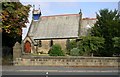
St Lawrence Church - Otley Road, Eldwick
Image: © Betty Longbottom
Taken: 10 Oct 2007
0.10 miles