IMAGES TAKEN NEAR TO
Hill Top Lane, BINGLEY, BD16 3GQ
Introduction
This page details the photographs taken nearby to Hill Top Lane, BD16 3GQ by members of the Geograph project.
The Geograph project started in 2005 with the aim of publishing, organising and preserving representative images for every square kilometre of Great Britain, Ireland and the Isle of Man.

There are currently over 7.5m images from over14,400 individuals and you can help contribute to the project by visiting https://www.geograph.org.uk
Image Map (Loading...)


Getting Data...Please wait
Leaflet Map data © OpenStreetMap
Images are licensed for reuse under creativecommons.org/licenses/by-sa/2.0
Notes
- Clicking on the map will re-center to the selected point.
- The higher the marker number, the further away the image location is from the centre of the postcode.
Image Listing (14 Images Found)
Images are licensed for reuse under creativecommons.org/licenses/by-sa/2.0
Image
Details
Distance
1
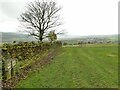
Valve markers near Hill Top Farm
The markers indicate a washout and air valve on a 400mm water main. This might either be a treated water main emanating from the nearby Graincliffe treatment works, or the raw water Nidd aqueduct that runs along this hillside. Close inspection of the 1936 map shows the Nidd to be about 60m west of here, so I'll go with it being the Graincliffe outlet to supply the Bingley area.
Image: © Stephen Craven
Taken: 16 Nov 2021
0.01 miles
2
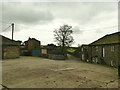
Hill Top Farm
The 17th century farmhouse (right) is grade II listed (list entry 1199512). Photo taken on the right of way that passes through the farmyard.
Image: © Stephen Craven
Taken: 16 Nov 2021
0.09 miles
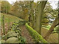
3
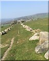
Hill Top Lane, Micklethwaite
The lane is supported on its south side by a retaining wall of huge boulders and is marked by these boulders. It runs from Carr Lane, just above the village, and fades out in a field below Hill Top Farm. It has no obvious function because it does not connect any significant points.
The village of East Morton is in the background with Rivock Edge on the skyline.
Image: © John Davies
Taken: 17 Apr 2019
0.12 miles
4
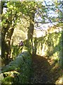
Footpath at Micklethwaite
Walled footpath above the village of Micklethwaite.
Image: © Gordon Hatton
Taken: 10 Nov 2013
0.18 miles
5
Fairlady Farm, Micklethwaite
The farm buildings are centred on a grade II listed cottage dated 1702 (list entry 1199911).
Image: © Stephen Craven
Taken: 16 Nov 2021
0.18 miles
6
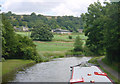
Leeds and Liverpool Canal near Micklethwaite
Looking east on the Leeds and Liverpool Canal, to the east of Morton Swing Bridge, near Micklethwaite, West Yorkshire. The photo was taken just outside the square, but the canal bend, the hillside and the village of Micklethwaite are all within SE1041.
Image: © Martin Clark
Taken: Unknown
0.19 miles
7
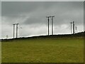
A plethora of power lines
In this view from Hill Top Lane there are three 3-phase lines, one of them left to right across the view and two at an angle to it; and also a higher voltage line in the distance.
Image: © Stephen Craven
Taken: 16 Nov 2021
0.20 miles
8
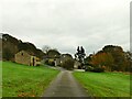
Access to Hill Top
Substantial access drive leading off Heights Lane to Hill Top.
Image: © Chris Heaton
Taken: 7 Feb 2014
0.21 miles
9
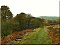
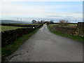
Hill Top Lane descending to Carr Lane
The woods to the left hide a long-disused quarry.
Image: © Stephen Craven
Taken: 16 Nov 2021
0.21 miles
10
Wood Lane near Micklethwaite
The lane is a public footpath, not a vehicular route.
Image: © Stephen Craven
Taken: 16 Nov 2021
0.22 miles