IMAGES TAKEN NEAR TO
Tewitt Lane, BINGLEY, BD16 3AJ
Introduction
This page details the photographs taken nearby to Tewitt Lane, BD16 3AJ by members of the Geograph project.
The Geograph project started in 2005 with the aim of publishing, organising and preserving representative images for every square kilometre of Great Britain, Ireland and the Isle of Man.

There are currently over 7.5m images from over14,400 individuals and you can help contribute to the project by visiting https://www.geograph.org.uk
Image Map (Loading...)


Getting Data...Please wait
Leaflet Map data © OpenStreetMap
Images are licensed for reuse under creativecommons.org/licenses/by-sa/2.0
Notes
- Clicking on the map will re-center to the selected point.
- The higher the marker number, the further away the image location is from the centre of the postcode.
Image Listing (39 Images Found)
Images are licensed for reuse under creativecommons.org/licenses/by-sa/2.0
Image
Details
Distance

2

Tewitt House
Spelled Tewet House on older maps. Tewit (or Peewit) is a Yorkshire name for a lapwing, an imitation of their call. The newer double garage to the left bears a crest with swords and chevrons (and some old dates, which I didn't note and can't read from the photo).
Image: © Stephen Craven
Taken: 16 Nov 2021
0.01 miles
3
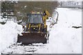
Clearing Tewitt Lane
4 Days after the March 2013 snowstorm, this JCB had been brought in by the owners of Tewitt House to clear the lane to their property.
Image: © Richard Kay
Taken: 27 Mar 2013
0.03 miles
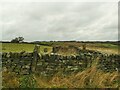
4
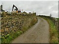
New drystone wall alongside Tewitt Lane
A new building was being constructed to the left, on raised ground supported by this retaining wall. The capstones are mortared but it is otherwise traditional dry stone construction.
Image: © Stephen Craven
Taken: 16 Nov 2021
0.03 miles
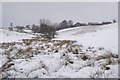
5
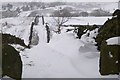
Bridleway to the Reservoir, Eldwick
The snowdrifts were created by the easterly wind during the storm of 22/23 March 2013. The switchback lane runs north-east towards the Compensation Reservoir in SE1241, visible in the upper right of the photo.
Image: © Richard Kay
Taken: 27 Mar 2013
0.07 miles
6
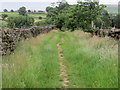
Enclosed Footpath to the east of Tewitt House
Looking south-eastward.
Image: © Peter Wood
Taken: 22 Jun 2017
0.08 miles
7
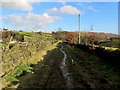
Walled Track leading to Eldwick Beck
Public footpath from Tewitt House, squeezed between parallel dry stone walls which descends towards the waters of Eldwick Beck.
Image: © Chris Heaton
Taken: 7 Feb 2014
0.09 miles
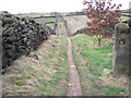
8
Blocked track off Tewitt Lane
Access to this walled track has been stopped up.
Image: © Stephen Craven
Taken: 16 Nov 2021
0.10 miles
9
Rollercoaster lane
The lane is paved with causey stones for most of its length and goes up and down quite dramatically.
Image: © John Illingworth
Taken: 27 Mar 2015
0.10 miles
10
Tewitt Farm, Eldwick from the east
The unnamed beck in the photo, leading up to the farm is a tributary of Eldwick Beck. Notice the change in vegetation away from the watercourse. The sharp-eyed will pick out the JCB clearing Tewitt Lane - see photo Image
Image: © Richard Kay
Taken: 27 Mar 2013
0.10 miles