IMAGES TAKEN NEAR TO
Heights Lane, BINGLEY, BD16 3AG
Introduction
This page details the photographs taken nearby to Heights Lane, BD16 3AG by members of the Geograph project.
The Geograph project started in 2005 with the aim of publishing, organising and preserving representative images for every square kilometre of Great Britain, Ireland and the Isle of Man.

There are currently over 7.5m images from over14,400 individuals and you can help contribute to the project by visiting https://www.geograph.org.uk
Image Map (Loading...)


Getting Data...Please wait
Leaflet Map data © OpenStreetMap
Images are licensed for reuse under creativecommons.org/licenses/by-sa/2.0
Notes
- Clicking on the map will re-center to the selected point.
- The higher the marker number, the further away the image location is from the centre of the postcode.
Image Listing (10 Images Found)
Images are licensed for reuse under creativecommons.org/licenses/by-sa/2.0
Image
Details
Distance
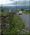
2
Junction of Otley Road and Heights Lane
The road was wet after a brief but intense shower.
Image: © Stephen Craven
Taken: 25 Jul 2020
0.17 miles
3
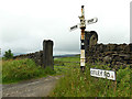
Roadsign at the junction of Otley Road and Heights Lane
This sign to Morton and Otley has lost its third arm, which probably read "Bingley".
Image: © Stephen Craven
Taken: 25 Jul 2020
0.17 miles
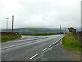
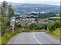
4
Otley Road descending towards East Morton
Image: © Mat Fascione
Taken: 3 Aug 2017
0.18 miles
5
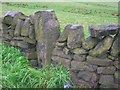
Old Milestone by Otley Road, Bingley Parish
By the UC road, in parish of Bingley (Bradford District), Otley Road, just West of Heights Lane, in wall near '17% Low Gear' sign, 'SLOW' on road.
Surveyed
Milestone Society National ID: YW_XBINb.
Image: © Milestone Society
Taken: Unknown
0.20 miles
6
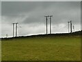
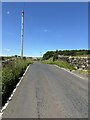
A plethora of power lines
In this view from Hill Top Lane there are three 3-phase lines, one of them left to right across the view and two at an angle to it; and also a higher voltage line in the distance.
Image: © Stephen Craven
Taken: 16 Nov 2021
0.20 miles
7
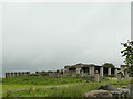
Farm buildings off Otley Road
Unusually, built with concrete block walls and slate roofs.
Image: © Stephen Craven
Taken: 25 Jul 2020
0.22 miles
8
Otley Road descending towards East Morton
Image: © Mat Fascione
Taken: 3 Aug 2017
0.22 miles
9
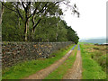
Track coming off the moors
The track leads onto Otley Road. To the left is a wooded former quarry site.
Image: © Stephen Craven
Taken: 25 Jul 2020
0.25 miles
10
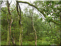
A view into the woods
Looking over a stone wall into an area marked on large scale maps as a former quarry (named as Fowls Delf on Open Street Map).
Image: © Stephen Craven
Taken: 25 Jul 2020
0.25 miles