IMAGES TAKEN NEAR TO
Edward Street, BINGLEY, BD16 2PF
Introduction
This page details the photographs taken nearby to Edward Street, BD16 2PF by members of the Geograph project.
The Geograph project started in 2005 with the aim of publishing, organising and preserving representative images for every square kilometre of Great Britain, Ireland and the Isle of Man.

There are currently over 7.5m images from over14,400 individuals and you can help contribute to the project by visiting https://www.geograph.org.uk
Image Map (Loading...)


Getting Data...Please wait
Leaflet Map data © OpenStreetMap
Images are licensed for reuse under creativecommons.org/licenses/by-sa/2.0
Notes
- Clicking on the map will re-center to the selected point.
- The higher the marker number, the further away the image location is from the centre of the postcode.
Image Listing (209 Images Found)
Images are licensed for reuse under creativecommons.org/licenses/by-sa/2.0
Image
Details
Distance
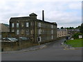
3
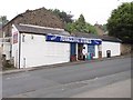
Rob's Plaice - Fish & Chips - Crownest Lane
Image: © Betty Longbottom
Taken: 29 Sep 2012
0.03 miles
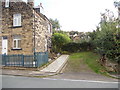
4
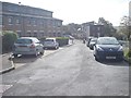
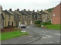
Edward Street - looking towards Ferncliffe Road
Image: © Betty Longbottom
Taken: 29 Sep 2012
0.04 miles
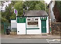
5
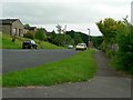
Ferncliffe Stores - Ferncliffe Road
Image: © Betty Longbottom
Taken: 20 Aug 2012
0.04 miles
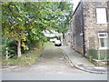
9
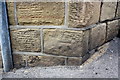
Benchmark on wall of #5 Ferncliffe Road at junction with Mornington Road
Ordnance Survey cut mark benchmark described on the Bench Mark Database at http://www.bench-marks.org.uk/bm38551
Image: © Roger Templeman
Taken: 30 Jun 2011
0.06 miles