IMAGES TAKEN NEAR TO
The Grove, BINGLEY, BD16 2ET
Introduction
This page details the photographs taken nearby to The Grove, BD16 2ET by members of the Geograph project.
The Geograph project started in 2005 with the aim of publishing, organising and preserving representative images for every square kilometre of Great Britain, Ireland and the Isle of Man.

There are currently over 7.5m images from over14,400 individuals and you can help contribute to the project by visiting https://www.geograph.org.uk
Image Map (Loading...)


Getting Data...Please wait
Leaflet Map data © OpenStreetMap
Images are licensed for reuse under creativecommons.org/licenses/by-sa/2.0
Notes
- Clicking on the map will re-center to the selected point.
- The higher the marker number, the further away the image location is from the centre of the postcode.
Image Listing (148 Images Found)
Images are licensed for reuse under creativecommons.org/licenses/by-sa/2.0
Image
Details
Distance
1
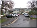
Crossflatts Primary School - Morton Lane
Image: © Betty Longbottom
Taken: 13 Jan 2009
0.03 miles
7
Allotment gardens, Micklethwaite
The allotments are on sloping ground on the north side of the canal.
Image: © Gordon Hatton
Taken: 10 Nov 2013
0.10 miles
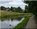
8

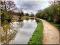
Walking along the Leeds to Liverpool Canal #211
Heading towards Keighley.
Image: © Ian S
Taken: 18 Sep 2010
0.10 miles
9
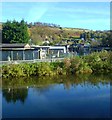
Leeds and Liverpool Canal at Crossflatts
Image: © Mat Fascione
Taken: 3 Aug 2017
0.10 miles