IMAGES TAKEN NEAR TO
Keighley Road, BINGLEY, BD16 2ER
Introduction
This page details the photographs taken nearby to Keighley Road, BD16 2ER by members of the Geograph project.
The Geograph project started in 2005 with the aim of publishing, organising and preserving representative images for every square kilometre of Great Britain, Ireland and the Isle of Man.

There are currently over 7.5m images from over14,400 individuals and you can help contribute to the project by visiting https://www.geograph.org.uk
Image Map (Loading...)


Getting Data...Please wait
Leaflet Map data © OpenStreetMap
Images are licensed for reuse under creativecommons.org/licenses/by-sa/2.0
Notes
- Clicking on the map will re-center to the selected point.
- The higher the marker number, the further away the image location is from the centre of the postcode.
Image Listing (99 Images Found)
Images are licensed for reuse under creativecommons.org/licenses/by-sa/2.0
Image
Details
Distance
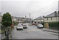
1
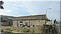
Former barn to Ryshworth Hall Farm
Now converted to residential use
Image: © Kevin Waterhouse
Taken: 18 Oct 2023
0.02 miles
4
Ryshworth Bridge 4-40 - Keighley Road
Image: © Betty Longbottom
Taken: 13 Jan 2009
0.04 miles
7
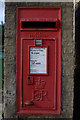
Elizabeth II Postbox, Morton Lane Shops
Image: © Mark Anderson
Taken: 24 Oct 2010
0.06 miles
8
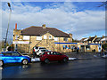
Bengal Tiffin / Tesco Express, Morton Lane, Crossflatts
The supermarket has expanded into an extension of the original building.
Image: © Stephen Craven
Taken: 2 Feb 2019
0.06 miles
9
Morton Lane Shops
A closer view of the postbox can be seen here: Image
Image: © Mark Anderson
Taken: 24 Oct 2010
0.07 miles