IMAGES TAKEN NEAR TO
Aire Street, BINGLEY, BD16 2BQ
Introduction
This page details the photographs taken nearby to Aire Street, BD16 2BQ by members of the Geograph project.
The Geograph project started in 2005 with the aim of publishing, organising and preserving representative images for every square kilometre of Great Britain, Ireland and the Isle of Man.

There are currently over 7.5m images from over14,400 individuals and you can help contribute to the project by visiting https://www.geograph.org.uk
Image Map (135 Images)


Getting Data...Please wait
Leaflet Map data © OpenStreetMap
Images are licensed for reuse under creativecommons.org/licenses/by-sa/2.0
Notes
- Clicking on the map will re-center to the selected point.
- The higher the marker number, the further away the image location is from the centre of the postcode.
Image Listing (135 Images Found)
Images are licensed for reuse under creativecommons.org/licenses/by-sa/2.0
Image
Details
Distance
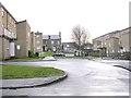
1
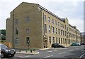
Limefield Mills - Micklethwaite Lane
Image: © Betty Longbottom
Taken: 6 Jun 2008
0.03 miles
3
St Aidan's Church - Canal Road, Crossflatts
Image: © Betty Longbottom
Taken: 6 Jun 2008
0.04 miles
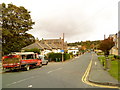
4
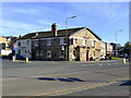
The Royal, Crossflatts, Bingley
Regular Tetley local
Image: © al partington
Taken: 3 Nov 2006
0.04 miles
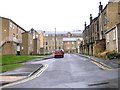
5
St Aidan's Square - Micklethwaite Lane
Image: © Betty Longbottom
Taken: 13 Jan 2009
0.04 miles

8
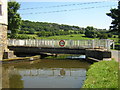
Micklethwaite Swing Bridge, Crossflatts
Over the Leeds and Liverpool Canal
Image: © Mark Morton
Taken: 9 Jul 2005
0.05 miles

10
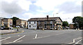
The Royal, Keighley Road (B6265), Crossflatts
Image: © habiloid
Taken: 6 Aug 2022
0.05 miles