IMAGES TAKEN NEAR TO
Castlefields, BINGLEY, BD16 2AE
Introduction
This page details the photographs taken nearby to Castlefields, BD16 2AE by members of the Geograph project.
The Geograph project started in 2005 with the aim of publishing, organising and preserving representative images for every square kilometre of Great Britain, Ireland and the Isle of Man.

There are currently over 7.5m images from over14,400 individuals and you can help contribute to the project by visiting https://www.geograph.org.uk
Image Map (Loading...)


Getting Data...Please wait
Leaflet Map data © OpenStreetMap
Images are licensed for reuse under creativecommons.org/licenses/by-sa/2.0
Notes
- Clicking on the map will re-center to the selected point.
- The higher the marker number, the further away the image location is from the centre of the postcode.
Image Listing (48 Images Found)
Images are licensed for reuse under creativecommons.org/licenses/by-sa/2.0
Image
Details
Distance
1
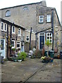
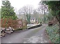
Seventeenth Century cottages, Castlefields
The mill-workers' cottages back on to the 17th Century mill-master's house, now Castlefields Hall.
The stone-flagged yard has a stone gulley draining it.
Image: © John Davies
Taken: 5 Jan 2015
0.06 miles
2
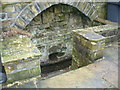
Well in courtyard of cottages
The well is sunken in the wall of the courtyard by the 17th Century cottages on Castlefields Lane, Bingley.
Surprisingly, the well is only about 10 metres from the river.
Image: © John Davies
Taken: 5 Jan 2015
0.06 miles
3
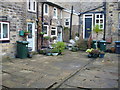
Cottages, Castlefields Lane, Bingley
Seventeenth Century mill workers cottages backing on to the millmasters house, presumably the owner of Castlefields Mill .
There is an interesting stone gulley draining the stone-flagged yard.
Image: © John Davies
Taken: 5 Jan 2015
0.06 miles
4
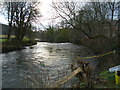
River Aire at Castlefields, Bingley
Just below this point the river veers South round the mass of Bailey Hills.
Image: © John Davies
Taken: 5 Jan 2015
0.06 miles
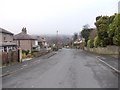
5
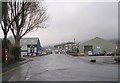
Castlefields Road - Castlefields Lane
Image: © Betty Longbottom
Taken: 13 Jan 2009
0.08 miles
7
Bend in the River Aire
The river is turned southwards by the mass of Bailey Hills, before resuming its eastward course.
Image: © John Davies
Taken: 5 Jan 2015
0.10 miles
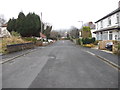
8
Castlefields Lane - looking towards Keighley Road
Image: © Betty Longbottom
Taken: 9 Jan 2013
0.10 miles
9
Longwood Avenue - looking towards Keighley Road
Image: © Betty Longbottom
Taken: 9 Jan 2013
0.11 miles
10
Laurel Grove - looking towards Keighley Road
Image: © Betty Longbottom
Taken: 9 Jan 2013
0.11 miles