IMAGES TAKEN NEAR TO
Main Street, BINGLEY, BD16 1SE
Introduction
This page details the photographs taken nearby to Main Street, BD16 1SE by members of the Geograph project.
The Geograph project started in 2005 with the aim of publishing, organising and preserving representative images for every square kilometre of Great Britain, Ireland and the Isle of Man.

There are currently over 7.5m images from over14,400 individuals and you can help contribute to the project by visiting https://www.geograph.org.uk
Image Map
Images are licensed for reuse under creativecommons.org/licenses/by-sa/2.0
Notes
- Clicking on the map will re-center to the selected point.
- The higher the marker number, the further away the image location is from the centre of the postcode.
Image Listing (68 Images Found)
Images are licensed for reuse under creativecommons.org/licenses/by-sa/2.0
Image
Details
Distance
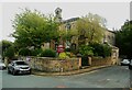
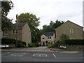
3
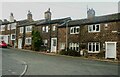
Houses on the lower end of Smith Street, Cottingley
These are typical of the houses in the old village.
Image: © Humphrey Bolton
Taken: 25 Sep 2023
0.03 miles
4
Hollings Street - Bradford Old Road
Image: © Betty Longbottom
Taken: 2 Oct 2010
0.04 miles
5
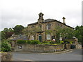
Cottingley Town Hall, Church & Community Centre,
Grade 2 Listed. Built 1864.
Image: © Stephen Armstrong
Taken: 15 May 2011
0.04 miles
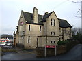
7
The Town Hall, Cottingley
This is also a church, and has been since it was built.
Image: © Humphrey Bolton
Taken: 25 Sep 2023
0.05 miles
8

Texaco Filling Station - Cottingley New Road
Image: © Betty Longbottom
Taken: 28 Dec 2007
0.05 miles
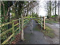
10
Old Vicarage Close - Cottingley Moor Road
Image: © Betty Longbottom
Taken: 2 Oct 2010
0.05 miles