IMAGES TAKEN NEAR TO
North Walk, BINGLEY, BD16 1RY
Introduction
This page details the photographs taken nearby to North Walk, BD16 1RY by members of the Geograph project.
The Geograph project started in 2005 with the aim of publishing, organising and preserving representative images for every square kilometre of Great Britain, Ireland and the Isle of Man.

There are currently over 7.5m images from over14,400 individuals and you can help contribute to the project by visiting https://www.geograph.org.uk
Image Map (Loading...)


Getting Data...Please wait
Leaflet Map data © OpenStreetMap
Images are licensed for reuse under creativecommons.org/licenses/by-sa/2.0
Notes
- Clicking on the map will re-center to the selected point.
- The higher the marker number, the further away the image location is from the centre of the postcode.
Image Listing (31 Images Found)
Images are licensed for reuse under creativecommons.org/licenses/by-sa/2.0
Image
Details
Distance
4
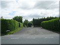
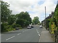
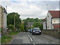
Long Lane - viewed from North Walk
Image: © Betty Longbottom
Taken: 22 Jun 2009
0.08 miles
5
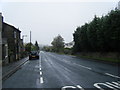
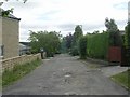
Long Lane - viewed from North Walk
Image: © Betty Longbottom
Taken: 22 Jun 2009
0.08 miles
7
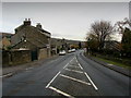
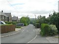
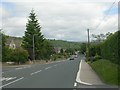
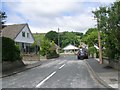
Entering Harden
B6429 entering Harden as Long Lane from the south west.
Image: © Chris Heaton
Taken: 8 Nov 2013
0.09 miles
10
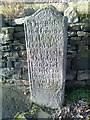
Old Boundary Marker by the B6429, Hill End Lane, Harden
Estate Boundary Marker by the B6429, in parish of Cullingworth (Bradford District), Harden, at junction of Hill End Lane with Ryecroft Lane.
Inscription almost indecipherable, but seems to refer to local landowner 'Benjamin Ferrand Esq.' of Harden Hall, and is dated '1783'.
Grade II Listed.
List Entry Number: 1133396 https://historicengland.org.uk/listing/the-list/list-entry/1133396
Surveyed
Milestone Society National ID: YW_CULL02em
Image: © Milestone Society
Taken: Unknown
0.12 miles