IMAGES TAKEN NEAR TO
Westwood Crescent, BINGLEY, BD16 1NN
Introduction
This page details the photographs taken nearby to Westwood Crescent, BD16 1NN by members of the Geograph project.
The Geograph project started in 2005 with the aim of publishing, organising and preserving representative images for every square kilometre of Great Britain, Ireland and the Isle of Man.

There are currently over 7.5m images from over14,400 individuals and you can help contribute to the project by visiting https://www.geograph.org.uk
Image Map (Loading...)


Getting Data...Please wait
Leaflet Map data © OpenStreetMap
Images are licensed for reuse under creativecommons.org/licenses/by-sa/2.0
Notes
- Clicking on the map will re-center to the selected point.
- The higher the marker number, the further away the image location is from the centre of the postcode.
Image Listing (63 Images Found)
Images are licensed for reuse under creativecommons.org/licenses/by-sa/2.0
Image
Details
Distance
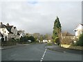
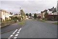
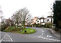
3
Grange Park Road - viewed from Westwood Crescent
Image: © Betty Longbottom
Taken: 13 Jan 2009
0.06 miles
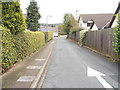
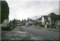
6
Grange Park Road - viewed from Eastwood Crescent
Image: © Betty Longbottom
Taken: 13 Jan 2009
0.08 miles
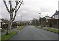
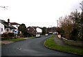
9
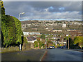
Ghyll Wood Drive, Cottingley
Looking down the fairly steep road and across the Aire Valley towards Gilstead.
Image: © Stephen Craven
Taken: 25 Dec 2019
0.10 miles