IMAGES TAKEN NEAR TO
Wagon Lane, BINGLEY, BD16 1LT
Introduction
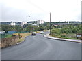
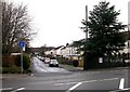
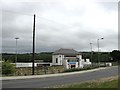
This page details the photographs taken nearby to Wagon Lane, BD16 1LT by members of the Geograph project.
The Geograph project started in 2005 with the aim of publishing, organising and preserving representative images for every square kilometre of Great Britain, Ireland and the Isle of Man.

There are currently over 7.5m images from over14,400 individuals and you can help contribute to the project by visiting https://www.geograph.org.uk
Image Map (Loading...)


Getting Data...Please wait
Leaflet Map data © OpenStreetMap
Images are licensed for reuse under creativecommons.org/licenses/by-sa/2.0
Notes
- Clicking on the map will re-center to the selected point.
- The higher the marker number, the further away the image location is from the centre of the postcode.
Image Listing (78 Images Found)
Images are licensed for reuse under creativecommons.org/licenses/by-sa/2.0
Image
Details
Distance
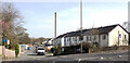
2
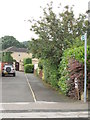
Ash Grove - looking towards Bradford Road
Image: © Betty Longbottom
Taken: 20 Aug 2012
0.05 miles
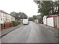
3
Wagon Lane - viewed from Dowley Gap Lane
Image: © Betty Longbottom
Taken: 20 Aug 2012
0.05 miles
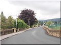
5
Dowley Gap Lane - viewed from Wagon Lane
Image: © Betty Longbottom
Taken: 20 Aug 2012
0.06 miles
7
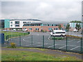
Beckfoot School - viewed from Dowley Gap Lane
Image: © Betty Longbottom
Taken: 20 Aug 2012
0.08 miles
8

Northern Arch of the River Aire Bridge
An elaborate Victorian structure as part of the Nidd Valley water supply to Bradford
Image: © Kevin Waterhouse
Taken: 27 Apr 2022
0.08 miles
9
Bradford & Bingley Sports Club, Wagon Lane
Image: © Stephen Armstrong
Taken: 15 May 2011
0.08 miles
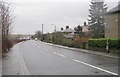
10
Ash Grove seen from Bradford Road (B6265), Bingley
Image: © habiloid
Taken: 30 Mar 2021
0.08 miles