IMAGES TAKEN NEAR TO
Progress Avenue, BINGLEY, BD16 1LG
Introduction
This page details the photographs taken nearby to Progress Avenue, BD16 1LG by members of the Geograph project.
The Geograph project started in 2005 with the aim of publishing, organising and preserving representative images for every square kilometre of Great Britain, Ireland and the Isle of Man.

There are currently over 7.5m images from over14,400 individuals and you can help contribute to the project by visiting https://www.geograph.org.uk
Image Map (Loading...)


Getting Data...Please wait
Leaflet Map data © OpenStreetMap
Images are licensed for reuse under creativecommons.org/licenses/by-sa/2.0
Notes
- Clicking on the map will re-center to the selected point.
- The higher the marker number, the further away the image location is from the centre of the postcode.
Image Listing (86 Images Found)
Images are licensed for reuse under creativecommons.org/licenses/by-sa/2.0
Image
Details
Distance
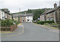
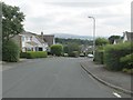
5
Millbeck Drive - looking towards Keighley Road
Image: © Betty Longbottom
Taken: 20 Jul 2013
0.07 miles
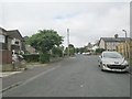
6
Parry Close - looking towards Gatesway
Image: © Betty Longbottom
Taken: 20 Jul 2013
0.07 miles
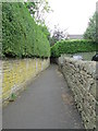
8
Poplar Grove - looking towards Cliffe Avenue
Image: © Betty Longbottom
Taken: 20 Jul 2013
0.08 miles
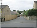
9
Effingham Road - viewed from Cliffe Avenue
Image: © Betty Longbottom
Taken: 20 Jul 2013
0.08 miles
10
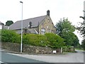
Former school or Sunday School, Keighley Road, Harden
Note the belfry, and the plaque on the small gable, shown here: Image
Image: © Humphrey Bolton
Taken: 6 Sep 2008
0.09 miles