IMAGES TAKEN NEAR TO
Cuckoo Nest, BINGLEY, BD16 1BD
Introduction
This page details the photographs taken nearby to Cuckoo Nest, BD16 1BD by members of the Geograph project.
The Geograph project started in 2005 with the aim of publishing, organising and preserving representative images for every square kilometre of Great Britain, Ireland and the Isle of Man.

There are currently over 7.5m images from over14,400 individuals and you can help contribute to the project by visiting https://www.geograph.org.uk
Image Map (Loading...)


Getting Data...Please wait
Leaflet Map data © OpenStreetMap
Images are licensed for reuse under creativecommons.org/licenses/by-sa/2.0
Notes
- Clicking on the map will re-center to the selected point.
- The higher the marker number, the further away the image location is from the centre of the postcode.
Image Listing (48 Images Found)
Images are licensed for reuse under creativecommons.org/licenses/by-sa/2.0
Image
Details
Distance
1
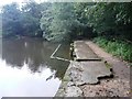
Baxter's Pond
Small pond above Cuckoo Nest Cottages, on a stream running down from the much larger Coppice Pond on the St. Ives Estate. The pond was dedicated to John Baxter in 2004 in recognition of his work re-establishing the pond and to celebrate forty years of service to the St. Ives Estate and Bradford Council.
Image: © Paul Glazzard
Taken: 21 Mar 2007
0.02 miles
2
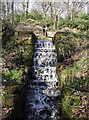
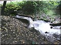
Baxter's Pond
Cascade below the small pond at Cuckoo Nest Cottages, on a stream running down from the much larger Coppice Pond on the St. Ives Estate. The pond was dedicated to John Baxter in 2004 in recognition of his work re-establishing the pond and to celebrate forty years of service to the St. Ives Estate and Bradford Council.
Image: © Paul Glazzard
Taken: 21 Mar 2007
0.03 miles
3
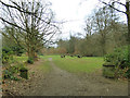
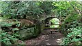
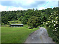
Picnic area on the St Ives Estate
The pair of stone gateposts once marked the start of a path leading straight to the Mansion.
Image: © Stephen Craven
Taken: 13 Jan 2018
0.07 miles
4
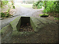
Dry cistern on the St Ives Estate
The exact function of this stone cistern is unclear.
Image: © Stephen Craven
Taken: 13 Jan 2018
0.07 miles
5
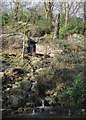
Outlet of Coppice Pond, St Ives Estate, Harden
The outlet is through a series of culverts, which join together downstream to pass under the driveway. It is guarded by a weir, which catches debris. Although there is only a shallow depth of flow over the weir, this results in a strong flow into the watercourse downstream (see Image).
Image: © Humphrey Bolton
Taken: 6 Sep 2008
0.08 miles
6
Outflow from Coppice Pond, St Ives Estate, Harden
This turbulent flow comes from the placid water at the outlet of the pond. (See Image)
Image: © Humphrey Bolton
Taken: 6 Sep 2008
0.08 miles
7
Private Estate Track to Coppice Pond
For the owners of St Ives, a rock cut track with an underpass of the road to lead to the pond (and former garden)
Image: © Kevin Waterhouse
Taken: 15 Jun 2022
0.08 miles
8
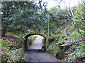
Pedestrian subway on the St Ives Estate
The subway takes a path from the Mansion to the Coppice Pond beneath the main drive.
Image: © Stephen Craven
Taken: 13 Jan 2018
0.08 miles
9
Calder/Aire Bridleway Route, Wood Bank
Here we are looking north up a bridleway leading into the St Ives estate to the west of Bingley. The Calder/Aire Route is a 17-mile trail using bridleways and quiet lanes that links Bingley to the Pennine Bridleway National Trail at Widdop.
Image: © michael ely
Taken: 19 Jun 2008
0.09 miles
10
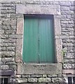
Taking-in doorway, Home Farm, St Ives Estate, Harden
This has a re-used 17C lintel, dated 1670, and a sill dated 1870.
Image: © Humphrey Bolton
Taken: 6 Sep 2008
0.09 miles