IMAGES TAKEN NEAR TO
Harris Street, BRADFORD, BD1 5HZ
Introduction
This page details the photographs taken nearby to Harris Street, BD1 5HZ by members of the Geograph project.
The Geograph project started in 2005 with the aim of publishing, organising and preserving representative images for every square kilometre of Great Britain, Ireland and the Isle of Man.

There are currently over 7.5m images from over14,400 individuals and you can help contribute to the project by visiting https://www.geograph.org.uk
Image Map
Images are licensed for reuse under creativecommons.org/licenses/by-sa/2.0
Notes
- Clicking on the map will re-center to the selected point.
- The higher the marker number, the further away the image location is from the centre of the postcode.
Image Listing (492 Images Found)
Images are licensed for reuse under creativecommons.org/licenses/by-sa/2.0
Image
Details
Distance
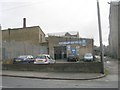
1
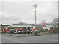
Harris Street Waste Management Department Depot - Harris Street
Image: © Betty Longbottom
Taken: 22 Nov 2010
0.02 miles
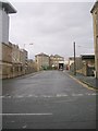
2
Harris Street
There is an OS Cut Benchmark on the single storey building, approximately in the middle, just above the black waste pipe at ground level.
Image: © Stephen Armstrong
Taken: 13 May 2017
0.03 miles
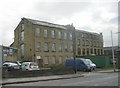
3
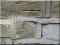
OS Cut Benchmark, 94 Harris Street
A damaged Cut Mark (the bottom of the arrow is missing) on the wall of 94 Harris Street. Details at http://www.bench-marks.org.uk/bm86492
Image: © Stephen Armstrong
Taken: 13 May 2017
0.04 miles
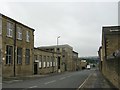
5
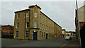
Former Woollen Mill, Harris Street, Bradford
Inscribed THS 1906 at the top of the angled corner. I have often passed this building wondering what the letters THS stood for. The sign above the door probably gives a clue - it says "opus Thirteen Harris St." Opus Photografix are the occupiers, and the address is 13 Harris Street.
Image: © Stephen Armstrong
Taken: 25 Sep 2022
0.05 miles
7
N F Palmer & Son Autoengineers - Harris Street
Image: © Betty Longbottom
Taken: 22 Nov 2010
0.05 miles
8
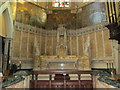
St Mary's Catholic Church - East Parade - Altar area
This Church was closed on 11th Nov 2006 - plans are currently under consideration for converting it for use by the Emmaus Community in Bradford.
Image: © Betty Longbottom
Taken: 18 Apr 2013
0.06 miles
9
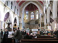
St Mary's Catholic Church - East Parade - looking towards the altar
This Church was closed on 11th Nov 2006 - plans are currently under consideration for converting it for use by the Emmaus Community in Bradford.
This shot was taken at an open evening for the project.
Image: © Betty Longbottom
Taken: 18 Apr 2013
0.06 miles
10

St Mary's RC Nursery Annexe, East Parade at A650 junction
There is an Ordnance Survey benchmark Image above the nearest pavement-level grill
Image: © Roger Templeman
Taken: 15 Jun 2017
0.06 miles