IMAGES TAKEN NEAR TO
Leeds Road, BRADFORD, BD1 5AF
Introduction
This page details the photographs taken nearby to Leeds Road, BD1 5AF by members of the Geograph project.
The Geograph project started in 2005 with the aim of publishing, organising and preserving representative images for every square kilometre of Great Britain, Ireland and the Isle of Man.

There are currently over 7.5m images from over14,400 individuals and you can help contribute to the project by visiting https://www.geograph.org.uk
Image Map
Images are licensed for reuse under creativecommons.org/licenses/by-sa/2.0
Notes
- Clicking on the map will re-center to the selected point.
- The higher the marker number, the further away the image location is from the centre of the postcode.
Image Listing (963 Images Found)
Images are licensed for reuse under creativecommons.org/licenses/by-sa/2.0
Image
Details
Distance
1
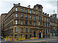
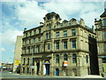
53-55 Leeds Road, Bradford
Former warehouse by Eli Milnes, 1859-62. Built in two phases, the tower, the top of which is quite ornate (Image]), marking the junction. Grade II listed.
Seemingly now known as Sunrise House, presumably having been converted to offices.
The dome on the right belongs to the Methodist Hall (Image]).
Image: © Stephen Richards
Taken: 14 Jun 2012
0.00 miles
2
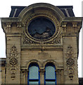
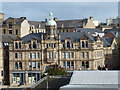
Detail of 53-55 Leeds Road, Bradford
The crowning stage of this building's tower Image] has carved and incised detail, all well above the normal eyeline. Time appears to have done for the clock face.
Image: © Stephen Richards
Taken: 14 Jun 2012
0.00 miles
3

Extremely weathered OS Cut Benchmark, 53 Leeds Road
This can be found (if you can see it) right of the door, on Leeds Road. Details at https://www.bench-marks.org.uk/bm27999. If you can't see it, it is cut across the white line.
Image: © Stephen Armstrong
Taken: 4 Nov 2018
0.01 miles
4

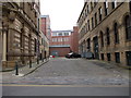
53 Leeds Road
Grade II Listed 1862, office / warehouse building on the edge of Little Germany. There is an extremely weathered, barely visible OS Cut Benchmark Image right of the door, under the street name sign. The street to the left of the building, (Vicar Lane) is one-way upwards to the rear corner of the building, but I have lost count the number of times I have met a vehicle coming the wrong way when I have driven up there. In fact, as can be seen, there are 2 vehicles parked the wrong way, which have obviously come through the No Entry sign just behind them!
Image: © Stephen Armstrong
Taken: 4 Nov 2018
0.01 miles

7
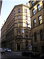
Devere House, Vicar Lane, Little Germany, Bradford
The home of Bradford Chamber of Commerce. One of many 19th Century warehouses in the immediate area. Many are still in commercial use as offices, but many have been converted for residential use. http://sites.google.com/site/allaboutbradford/little-germany
Image: © Stephen Armstrong
Taken: 1 Feb 2010
0.02 miles
8
Nos 53 & 55 Leeds Road, Bradford
Part of the mercantile district of "Little Germany" these Warehouses and offices were built in 1862.
Image: © Stanley Walker
Taken: 6 Aug 2009
0.02 miles
9
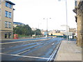
Bottom of Leeds Road
Looking towards Hall Ings & the city centre (or what's left of it) with Bradford's biggest attraction - the famous "Hole in the Ground" in the centre right of shot. It's normally very busy here, but not at 8.25 on Sunday morning.
Image: © Stephen Armstrong
Taken: 12 Sep 2010
0.02 miles
10
Bradford: Eastbrook Hall
Looking down on most of the frontage of this historic building, from the multi-storey car park of the nearby leisure complex.
Built in 1904 and first used as a Methodist Hall, Eastbrook Hall fell into disuse in the 1980s and its future bleakened by a major fire in 1996. Eight years later, though, plans were put in place to restore the building and it reopened in 2008 as university halls of residence, with business units as well.
Image: © Chris Downer
Taken: 29 Sep 2012
0.02 miles