IMAGES TAKEN NEAR TO
Burniston Close, BRADFORD, BD15 0LR
Introduction
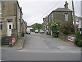
This page details the photographs taken nearby to Burniston Close, BD15 0LR by members of the Geograph project.
The Geograph project started in 2005 with the aim of publishing, organising and preserving representative images for every square kilometre of Great Britain, Ireland and the Isle of Man.

There are currently over 7.5m images from over14,400 individuals and you can help contribute to the project by visiting https://www.geograph.org.uk
Image Map
Images are licensed for reuse under creativecommons.org/licenses/by-sa/2.0
Notes
- Clicking on the map will re-center to the selected point.
- The higher the marker number, the further away the image location is from the centre of the postcode.
Image Listing (114 Images Found)
Images are licensed for reuse under creativecommons.org/licenses/by-sa/2.0
Image
Details
Distance
6
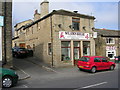
Wildsen Conservative Club - Wellington Street
Image: © Betty Longbottom
Taken: 3 Oct 2007
0.05 miles
10
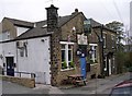
Wilsden House Takeaway - Main Street
Image: © Betty Longbottom
Taken: 12 Apr 2010
0.05 miles