IMAGES TAKEN NEAR TO
The Oaks, BRADFORD, BD15 0HH
Introduction
This page details the photographs taken nearby to The Oaks, BD15 0HH by members of the Geograph project.
The Geograph project started in 2005 with the aim of publishing, organising and preserving representative images for every square kilometre of Great Britain, Ireland and the Isle of Man.

There are currently over 7.5m images from over14,400 individuals and you can help contribute to the project by visiting https://www.geograph.org.uk
Image Map
Images are licensed for reuse under creativecommons.org/licenses/by-sa/2.0
Notes
- Clicking on the map will re-center to the selected point.
- The higher the marker number, the further away the image location is from the centre of the postcode.
Image Listing (65 Images Found)
Images are licensed for reuse under creativecommons.org/licenses/by-sa/2.0
Image
Details
Distance
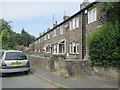
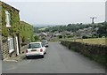
1
Stapper Green - viewed from Moss Row
Image: © Betty Longbottom
Taken: 12 Jul 2013
0.02 miles
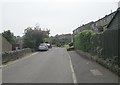
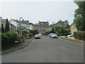
2
Stapper Green - viewed from Moss Row
Image: © Betty Longbottom
Taken: 12 Jul 2013
0.02 miles
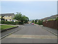
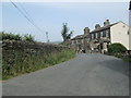
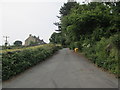
4
Wilsden Hill Road - viewed from Tan House Lane
Image: © Betty Longbottom
Taken: 12 Jul 2013
0.04 miles
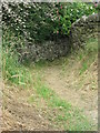
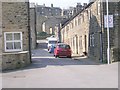
6
Tan House Lane - Wilsden Hill Road
Image: © Betty Longbottom
Taken: 12 Jul 2013
0.05 miles
8
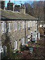
Mill cottages, Wilsden
Wilsden is a large village to the west of Bradford and is a mixture of agricultural heritage, 19th century mills and cottages, plus much modern commuter development.
Image: © Gordon Hatton
Taken: 7 Mar 2016
0.06 miles
9
Wilsden Hill Road - viewed from Tan House Lane
Image: © Betty Longbottom
Taken: 12 Jul 2013
0.06 miles