IMAGES TAKEN NEAR TO
Lee Close, BRADFORD, BD15 0ER
Introduction
This page details the photographs taken nearby to Lee Close, BD15 0ER by members of the Geograph project.
The Geograph project started in 2005 with the aim of publishing, organising and preserving representative images for every square kilometre of Great Britain, Ireland and the Isle of Man.

There are currently over 7.5m images from over14,400 individuals and you can help contribute to the project by visiting https://www.geograph.org.uk
Image Map
Images are licensed for reuse under creativecommons.org/licenses/by-sa/2.0
Notes
- Clicking on the map will re-center to the selected point.
- The higher the marker number, the further away the image location is from the centre of the postcode.
Image Listing (51 Images Found)
Images are licensed for reuse under creativecommons.org/licenses/by-sa/2.0
Image
Details
Distance
7
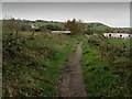
Bridleway leading towards Wilsden
Adopted by the Aire/Calder Link long distance footpath
Image: © Chris Heaton
Taken: 8 Nov 2013
0.08 miles
8
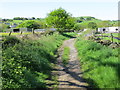
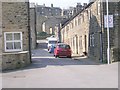
Cross Lane descending into Wilsden
Looking south-westward.
Image: © Peter Wood
Taken: 24 May 2016
0.08 miles