IMAGES TAKEN NEAR TO
Main Street, BRADFORD, BD15 0DX
Introduction
This page details the photographs taken nearby to Main Street, BD15 0DX by members of the Geograph project.
The Geograph project started in 2005 with the aim of publishing, organising and preserving representative images for every square kilometre of Great Britain, Ireland and the Isle of Man.

There are currently over 7.5m images from over14,400 individuals and you can help contribute to the project by visiting https://www.geograph.org.uk
Image Map
Images are licensed for reuse under creativecommons.org/licenses/by-sa/2.0
Notes
- Clicking on the map will re-center to the selected point.
- The higher the marker number, the further away the image location is from the centre of the postcode.
Image Listing (86 Images Found)
Images are licensed for reuse under creativecommons.org/licenses/by-sa/2.0
Image
Details
Distance
1
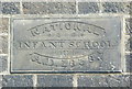
Datestone on the former National Infant School, Wilsden
I didn't know that there were schools for infants as far back as 1838, but I suppose they were provided so that the older members of the family could all work in the mills.
The following is copied from Waymarking.com:
Before the 1870 Education Act and the formation of local school boards, schools were often provided by churches of various denominations. National Schools were set up and run by the Church of England.
In this case the school was built purely for infants.
Revd. John Barber, the first vicar of Wilsden, began his infant school in 1837, and as the stone shows, the building was ready for use in 1838. This little school flourished for some years, particularly under the care of the highly regarded fourth vicar, Revd. Robert H Dover. Sadly, Mr Dover became ill, unable to take much part in parish life after 1859. The school declined and had closed by the time of Mr Dover’s death in 1863.
Later the old school had a variety of commercial users, including a renowned wheelwright, Joseph Charnock, until the 20th-century change in transport from horse and cart to motor vehicle had the inevitable effect on this business. As recently as the 1970s, the premises housed a patternmaker and woodworkers’ supplier.
It has now been converted into a house.
Image: © Humphrey Bolton
Taken: 5 Apr 2018
0.01 miles
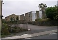
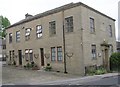
2
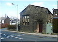
Former National Infant School, Wilsden
See Image for the datestone and information.
Image: © Humphrey Bolton
Taken: 5 Apr 2018
0.01 miles
6
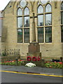
St Matthew's Church - Main Street, Wilsden
Image: © Betty Longbottom
Taken: 3 Oct 2007
0.03 miles
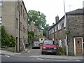
8
National Infant School - Main Street, Wilsden
Built 1838.
Image: © Betty Longbottom
Taken: 3 Oct 2007
0.03 miles
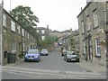
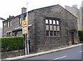
10
Mechanics' Institute - Main Street
Image: © Betty Longbottom
Taken: 22 Jun 2009
0.03 miles