IMAGES TAKEN NEAR TO
Lingfield Road, BRADFORD, BD15 0BB
Introduction
This page details the photographs taken nearby to Lingfield Road, BD15 0BB by members of the Geograph project.
The Geograph project started in 2005 with the aim of publishing, organising and preserving representative images for every square kilometre of Great Britain, Ireland and the Isle of Man.

There are currently over 7.5m images from over14,400 individuals and you can help contribute to the project by visiting https://www.geograph.org.uk
Image Map
Images are licensed for reuse under creativecommons.org/licenses/by-sa/2.0
Notes
- Clicking on the map will re-center to the selected point.
- The higher the marker number, the further away the image location is from the centre of the postcode.
Image Listing (114 Images Found)
Images are licensed for reuse under creativecommons.org/licenses/by-sa/2.0
Image
Details
Distance
3
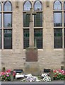
War Memorial - Main Street, Wilsden
Image: © Betty Longbottom
Taken: 3 Oct 2007
0.04 miles
5

Crack Lane 2 - viewed from Lingfield Road
Image: © Betty Longbottom
Taken: 6 Jul 2013
0.05 miles
6
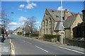
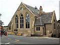
Former Wesleyan Sunday School, Wilsden
This is listed, Grade II, and the details state that it was built in 1890. There is a war memorial in front of it.
Image: © Humphrey Bolton
Taken: 5 Apr 2018
0.05 miles
8
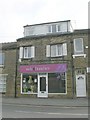
Wilsden Balti Tandoori - Main Street
Image: © Betty Longbottom
Taken: 12 Apr 2010
0.06 miles
9
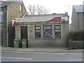
Albert Pratt Funeral Director - Main Street
Image: © Betty Longbottom
Taken: 12 Apr 2010
0.06 miles
10
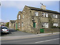
Wesleyan School, Wilsden
Built 1895. With the Wilsden War Memorial in front.
Image: © David Spencer
Taken: 15 Aug 2005
0.06 miles