IMAGES TAKEN NEAR TO
Cockin Lane, BRADFORD, BD14 6PZ
Introduction
This page details the photographs taken nearby to Cockin Lane, BD14 6PZ by members of the Geograph project.
The Geograph project started in 2005 with the aim of publishing, organising and preserving representative images for every square kilometre of Great Britain, Ireland and the Isle of Man.

There are currently over 7.5m images from over14,400 individuals and you can help contribute to the project by visiting https://www.geograph.org.uk
Image Map
Images are licensed for reuse under creativecommons.org/licenses/by-sa/2.0
Notes
- Clicking on the map will re-center to the selected point.
- The higher the marker number, the further away the image location is from the centre of the postcode.
Image Listing (21 Images Found)
Images are licensed for reuse under creativecommons.org/licenses/by-sa/2.0
Image
Details
Distance
3
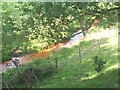
Hole Bottom Beck
Hole Bottom Beck, apparently running with tomato soup at this point on the "Bronte Way" between Clayton and Thornton.
Image: © Anonymous
Taken: 10 Sep 2006
0.11 miles
5

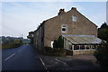
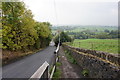
Chat Hill Road - viewed from Low Lane
Image: © Betty Longbottom
Taken: 1 Sep 2012
0.12 miles
7
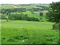
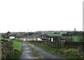
The Thornton valley
From a public footpath near to Thornton Hall.
Image: © Humphrey Bolton
Taken: 20 Aug 2010
0.13 miles
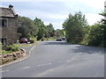
8
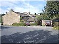
Thorntree Farm - viewed from Low Lane
Image: © Betty Longbottom
Taken: 1 Sep 2012
0.14 miles
9
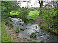
Hole Bottom Beck
The beck drains the hillside to the north of Clayton.
Image: © Stephen Craven
Taken: 12 Oct 2019
0.15 miles
10
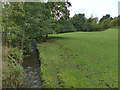
Pinch Beck
Looking upstream from Chat Hill Road bridge. See also Image
Image: © Stephen Craven
Taken: 12 Oct 2019
0.15 miles