IMAGES TAKEN NEAR TO
Manningham Lane, BRADFORD, BD1 3ES
Introduction
This page details the photographs taken nearby to Manningham Lane, BD1 3ES by members of the Geograph project.
The Geograph project started in 2005 with the aim of publishing, organising and preserving representative images for every square kilometre of Great Britain, Ireland and the Isle of Man.

There are currently over 7.5m images from over14,400 individuals and you can help contribute to the project by visiting https://www.geograph.org.uk
Image Map
Images are licensed for reuse under creativecommons.org/licenses/by-sa/2.0
Notes
- Clicking on the map will re-center to the selected point.
- The higher the marker number, the further away the image location is from the centre of the postcode.
Image Listing (268 Images Found)
Images are licensed for reuse under creativecommons.org/licenses/by-sa/2.0
Image
Details
Distance
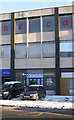
1
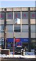
Swinton Insurance - Manningham Lane
Image: © Betty Longbottom
Taken: 7 Jan 2010
0.01 miles

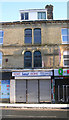
4
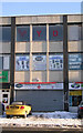
Mobile Phone & Accessories - Manningham Lane
Image: © Betty Longbottom
Taken: 7 Jan 2010
0.02 miles
5
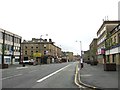
Manningham Lane
Very quiet at 9.00am on Saturday morning. Looking towards the city centre.
Image: © Stephen Armstrong
Taken: 16 Oct 2010
0.02 miles
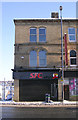
6
Sonali Bank (UK) Ltd - Manningham Lane
Image: © Betty Longbottom
Taken: 7 Jan 2010
0.02 miles
7
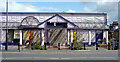
Former "Town & Country" club, Manningham Lane, Bradford
Image: © habiloid
Taken: 17 Aug 2014
0.02 miles
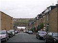
10
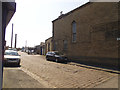
St Jude's Place, Manningham
This dead-end setted street is named after St Jude's church (Anglican) at its western end, built in 1843 "for the wealthier classes from Hanover Square and Peel Square" and demolished in 1968 by which time Manningham was far more deprived. Its site is now occupied by a car park.
In the distance is the chimney which is all that remains of Lumb Lane Mill (a.k.a. Drummond's Mill) Image
Image: © Stephen Craven
Taken: 27 May 2018
0.03 miles