IMAGES TAKEN NEAR TO
Westgate, BRADFORD, BD1 3AB
Introduction
This page details the photographs taken nearby to Westgate, BD1 3AB by members of the Geograph project.
The Geograph project started in 2005 with the aim of publishing, organising and preserving representative images for every square kilometre of Great Britain, Ireland and the Isle of Man.

There are currently over 7.5m images from over14,400 individuals and you can help contribute to the project by visiting https://www.geograph.org.uk
Image Map
Images are licensed for reuse under creativecommons.org/licenses/by-sa/2.0
Notes
- Clicking on the map will re-center to the selected point.
- The higher the marker number, the further away the image location is from the centre of the postcode.
Image Listing (343 Images Found)
Images are licensed for reuse under creativecommons.org/licenses/by-sa/2.0
Image
Details
Distance
1
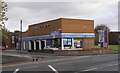
Cycle path from Westgate beside Auto Locksmiths premises
There is an Ordnance Survey benchmark Image on a corner stone in the wall left of the blue lamppost. The Security Centre in the compound was previously a police station
Image: © Roger Templeman
Taken: 17 Jun 2017
0.01 miles
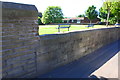
2
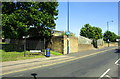
Benchmark on corner of wall at Westgate / Sedgwick Close
Ordnance Survey cut mark benchmark described on the Bench Mark Database at www.bench-marks.org.uk/bm85877
Image: © Roger Templeman
Taken: 17 Jun 2017
0.02 miles
4
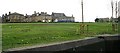
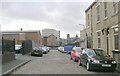
Site of the old Bradford Infirmary - Westgate
Now used as a recreation ground.
Image: © Betty Longbottom
Taken: 21 Apr 2007
0.04 miles
5
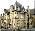
St Patrick's Catholic Church Presbytery - Westgate
Image: © Betty Longbottom
Taken: 21 Apr 2007
0.04 miles
6
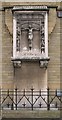
St Patrick's Catholic Church War Memorial
This contains 186 names of those soldiers and seamen from the parish who died in the First World War. The memorial is situated on the outside wall of the presbytery in Sedgefield Terrace.
Image: © Betty Longbottom
Taken: 21 Apr 2007
0.04 miles
7
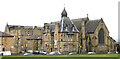
St Patrick's Church Complex - Westgate
Image: © Betty Longbottom
Taken: 21 Apr 2007
0.04 miles
8
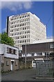
Provident Financial - Sunbridge Road
Image: © Betty Longbottom
Taken: 18 Apr 2007
0.04 miles
9
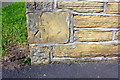
Playground on west side of Lumb Lane
There is an Ordnance Survey benchmark Image on the wall at its junction with a wall pier near the left hand edge of the image
Image: © Roger Templeman
Taken: 17 Jun 2017
0.04 miles