IMAGES TAKEN NEAR TO
Wood View Lane Ends, BRADFORD, BD13 5EB
Introduction
This page details the photographs taken nearby to Wood View Lane Ends, BD13 5EB by members of the Geograph project.
The Geograph project started in 2005 with the aim of publishing, organising and preserving representative images for every square kilometre of Great Britain, Ireland and the Isle of Man.

There are currently over 7.5m images from over14,400 individuals and you can help contribute to the project by visiting https://www.geograph.org.uk
Image Map
Images are licensed for reuse under creativecommons.org/licenses/by-sa/2.0
Notes
- Clicking on the map will re-center to the selected point.
- The higher the marker number, the further away the image location is from the centre of the postcode.
Image Listing (31 Images Found)
Images are licensed for reuse under creativecommons.org/licenses/by-sa/2.0
Image
Details
Distance
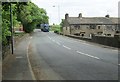
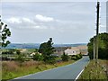
1
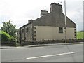
Wood View - Doctor's Bridge - Keighley Road
Image: © Betty Longbottom
Taken: 9 Jun 2014
0.01 miles
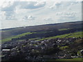
2
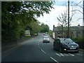
A629 Keighley Road south of Cullingworth
Image: © Colin Pyle
Taken: 24 May 2017
0.02 miles
3
View from Doctor's Bridge - Keighley Road
Image: © Betty Longbottom
Taken: 9 Jun 2014
0.02 miles
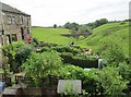
5
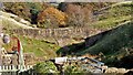
Masonry Aqueduct
The arches span Milking Hole Beck
Image: © Kevin Waterhouse
Taken: 26 Oct 2022
0.03 miles
9
View from Five Flags Car Park
A view, just after taking off from the Five Flags car park, towards the windmills atop Withens Moor.
Image: © Chris Barber
Taken: 7 Sep 2003
0.09 miles
10
Five Flags Hotel, Manywells Heights
At the junction of Trough Lane and the Halifax Road.
Image: © Christine Johnstone
Taken: 13 Jul 2011
0.11 miles