IMAGES TAKEN NEAR TO
Sunningdale Crescent, BRADFORD, BD13 5BA
Introduction
This page details the photographs taken nearby to Sunningdale Crescent, BD13 5BA by members of the Geograph project.
The Geograph project started in 2005 with the aim of publishing, organising and preserving representative images for every square kilometre of Great Britain, Ireland and the Isle of Man.

There are currently over 7.5m images from over14,400 individuals and you can help contribute to the project by visiting https://www.geograph.org.uk
Image Map
Images are licensed for reuse under creativecommons.org/licenses/by-sa/2.0
Notes
- Clicking on the map will re-center to the selected point.
- The higher the marker number, the further away the image location is from the centre of the postcode.
Image Listing (71 Images Found)
Images are licensed for reuse under creativecommons.org/licenses/by-sa/2.0
Image
Details
Distance
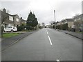
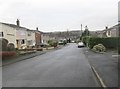
1
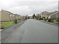
Sunningdale Crescent - looking towards Greenside Lane
Image: © Betty Longbottom
Taken: 3 Feb 2014
0.01 miles
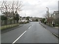
2
Westhill Avenue - looking towards Greenside Lane
Image: © Betty Longbottom
Taken: 3 Feb 2014
0.05 miles
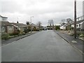
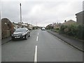
3
Westhill Avenue - Sunningdale Crescent
Image: © Betty Longbottom
Taken: 3 Feb 2014
0.06 miles
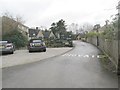
4
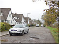
Hallas Lane, residential end
Despite the presence of houses one side of the road, it is unsurfaced, and therefore probably unadopted.
Image: © Stephen Craven
Taken: 28 Oct 2017
0.07 miles
5
Sunningdale Crescent - Greenside Lane
Image: © Betty Longbottom
Taken: 3 Feb 2014
0.07 miles
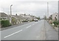
6
Sunningdale Crescent - Cullingworth Road
Image: © Betty Longbottom
Taken: 3 Feb 2014
0.07 miles

10
Hallowes Grove - looking towards Hallowes Park Road
Image: © Betty Longbottom
Taken: 3 Feb 2014
0.10 miles