IMAGES TAKEN NEAR TO
Wood View, BRADFORD, BD13 5AJ
Introduction
This page details the photographs taken nearby to Wood View, BD13 5AJ by members of the Geograph project.
The Geograph project started in 2005 with the aim of publishing, organising and preserving representative images for every square kilometre of Great Britain, Ireland and the Isle of Man.

There are currently over 7.5m images from over14,400 individuals and you can help contribute to the project by visiting https://www.geograph.org.uk
Image Map
Images are licensed for reuse under creativecommons.org/licenses/by-sa/2.0
Notes
- Clicking on the map will re-center to the selected point.
- The higher the marker number, the further away the image location is from the centre of the postcode.
Image Listing (85 Images Found)
Images are licensed for reuse under creativecommons.org/licenses/by-sa/2.0
Image
Details
Distance
1
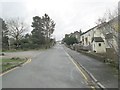
Parkside Terrace - looking towards Greenside Lane
Image: © Betty Longbottom
Taken: 3 Feb 2014
0.02 miles
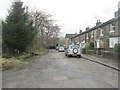
6
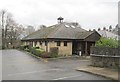
Cullingworth Methodist Church - Dellside Fold
Image: © Betty Longbottom
Taken: 3 Feb 2014
0.13 miles
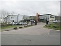
7
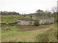
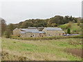
Woodfield Mill, Cullingworth
A former industrial building, now converted to housing.
Image: © Stephen Craven
Taken: 28 Oct 2017
0.13 miles
8
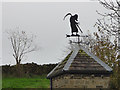
The grim reaper, Woodfield Mill, Cullingworth
A weathervane on a converted mill Image
Image: © Stephen Craven
Taken: 28 Oct 2017
0.13 miles
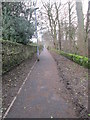
9

Hill End Lane (B6429) near to Cow House Bridge
Looking south-westward towards Cullingworth.
Image: © Peter Wood
Taken: 9 Jan 2019
0.14 miles
10
New housing, Woodfield Road, Cullingworth
Viewed from Bingley Road.
Image: © Stephen Craven
Taken: 28 Oct 2017
0.14 miles