IMAGES TAKEN NEAR TO
Trough Lane, BRADFORD, BD13 4NA
Introduction
This page details the photographs taken nearby to Trough Lane, BD13 4NA by members of the Geograph project.
The Geograph project started in 2005 with the aim of publishing, organising and preserving representative images for every square kilometre of Great Britain, Ireland and the Isle of Man.

There are currently over 7.5m images from over14,400 individuals and you can help contribute to the project by visiting https://www.geograph.org.uk
Image Map
Images are licensed for reuse under creativecommons.org/licenses/by-sa/2.0
Notes
- Clicking on the map will re-center to the selected point.
- The higher the marker number, the further away the image location is from the centre of the postcode.
Image Listing (2 Images Found)
Images are licensed for reuse under creativecommons.org/licenses/by-sa/2.0
Image
Details
Distance
1
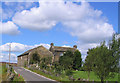
Trough Bottom Cullingworth
The houses at Trough Bottom are situated between two very sharp bends in the road
Image: © Mick Melvin
Taken: 20 Aug 2005
0.17 miles
2
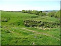
Track on Denholme Edge
The paths, tracks and fences on Denholme Edge do not always seem to tally with what is on the map, but I think this is a public footpath which leads to the bridleway at Booth House.
Image: © Humphrey Bolton
Taken: 24 Apr 2011
0.23 miles