IMAGES TAKEN NEAR TO
Denholme, BRADFORD, BD13 4LZ
Introduction
This page details the photographs taken nearby to BD13 4LZ by members of the Geograph project.
The Geograph project started in 2005 with the aim of publishing, organising and preserving representative images for every square kilometre of Great Britain, Ireland and the Isle of Man.

There are currently over 7.5m images from over14,400 individuals and you can help contribute to the project by visiting https://www.geograph.org.uk
Image Map
Images are licensed for reuse under creativecommons.org/licenses/by-sa/2.0
Notes
- Clicking on the map will re-center to the selected point.
- The higher the marker number, the further away the image location is from the centre of the postcode.
Image Listing (13 Images Found)
Images are licensed for reuse under creativecommons.org/licenses/by-sa/2.0
Image
Details
Distance
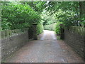
1
Private gated track off Trough Lane
Leading down to Field Head House.
Image: © Christine Johnstone
Taken: 13 Jul 2011
0.07 miles
2
![Hallas Rough Park [3]](https://s3.geograph.org.uk/geophotos/02/50/52/2505239_9e058991_120x120.jpg)
Hallas Rough Park [3]
Open access land north of Trough Lane. Part of Black Moor.
Image: © Christine Johnstone
Taken: 13 Jul 2011
0.08 miles
3
![Hallas Rough Park [1]](https://s1.geograph.org.uk/geophotos/02/50/52/2505233_f48e836f_120x120.jpg)
Hallas Rough Park [1]
Open access land north of Trough Lane. Part of Black Moor.
Image: © Christine Johnstone
Taken: 13 Jul 2011
0.11 miles
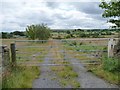
4
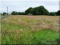
Grassy field and small wood
On the south side of Trough Lane.
Image: © Christine Johnstone
Taken: 13 Jul 2011
0.12 miles
5

Field Head House
Seen from Trough Lane.
Image: © Christine Johnstone
Taken: 13 Jul 2011
0.14 miles
6
![Hallas Rough Park [2]](https://s0.geograph.org.uk/geophotos/02/50/52/2505236_d84f0465_120x120.jpg)
Hallas Rough Park [2]
Open access land north of Trough Lane. Part of Black Moor.
Image: © Christine Johnstone
Taken: 13 Jul 2011
0.14 miles
7
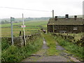
Track leading to Sand Beds Farm
Looking south-eastward.
Image: © Peter Wood
Taken: 30 Jun 2017
0.14 miles
8
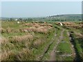
Bridleway on Black Moor, Cullingworth
This part of the moor is called Hallas Rough Park.
Image: © Humphrey Bolton
Taken: 21 Apr 2011
0.15 miles
9
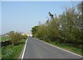
Trough Lane, Culingworth
The New Coley garden centre is on the right, which perhaps explains the shrubs planted in the verge.
Image: © Humphrey Bolton
Taken: 21 Apr 2011
0.19 miles