IMAGES TAKEN NEAR TO
Halifax Road, BRADFORD, BD13 4HU
Introduction
This page details the photographs taken nearby to Halifax Road, BD13 4HU by members of the Geograph project.
The Geograph project started in 2005 with the aim of publishing, organising and preserving representative images for every square kilometre of Great Britain, Ireland and the Isle of Man.

There are currently over 7.5m images from over14,400 individuals and you can help contribute to the project by visiting https://www.geograph.org.uk
Image Map (Loading...)


Getting Data...Please wait
Leaflet Map data © OpenStreetMap
Images are licensed for reuse under creativecommons.org/licenses/by-sa/2.0
Notes
- Clicking on the map will re-center to the selected point.
- The higher the marker number, the further away the image location is from the centre of the postcode.
Image Listing (13 Images Found)
Images are licensed for reuse under creativecommons.org/licenses/by-sa/2.0
Image
Details
Distance
1
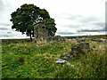
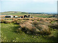
Ruins of Royd Hall, Denholme
One of the abandoned farms in this desolate area, their fields overgrown by rushes.
Image: © Humphrey Bolton
Taken: 27 Aug 2021
0.12 miles
2
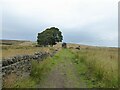
Bridleway approaching Peat Holes remains
Peat Holes appears to be an hill farm abandoned in the early part of the 20th century.
Image: © Kevin Waterhouse
Taken: 12 Aug 2024
0.14 miles
3
Ruined farm off Foreside Lane, Denholme
This farm is not been named on any of maps that I have seen. The farm in the distance is 'The Allotment'.
Image: © Humphrey Bolton
Taken: 26 Aug 2010
0.16 miles
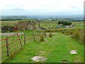
4
Remains of covered reservoir, Ogden
In a broad strip of rough pasture between Back Lane and the plantation on Great Scar. Soil Hill is in the distance.
Image: © Humphrey Bolton
Taken: 12 Apr 2009
0.17 miles
5
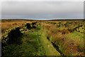
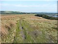
Green Lane above Ogden Clough
Bridleway from Ogden Reservoir, heading to cross Thornton Moor eventually emerging towards Oxenhope - an exhilarating walk.
Image: © Chris Heaton
Taken: 23 Nov 2016
0.18 miles
6
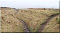
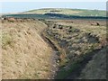
Old track across the moor
Sunken trackway on the moor above Ogden Reservoir. The track is now more of a drain and walkers tend to use the drier ground to the right.
Image: © Gordon Hatton
Taken: 30 Mar 2014
0.18 miles
7
Ruin off Foreside Lane, Denholme
This is part of a row of four buildings, as shown on old maps, none of which give its name. Judging by the large doorways the partly surviving building was a barn.
Image: © Humphrey Bolton
Taken: 30 Mar 2021
0.18 miles
8
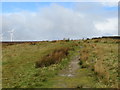
Footpath above Ogden Clough approaching Back Lane
Looking north-westward.
Image: © Peter Wood
Taken: 27 Apr 2017
0.19 miles
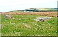
9
Track over Thornton Moor
A grassy track over Thornton Moor, here a gently sloping flat top to a ridge.
Image: © Humphrey Bolton
Taken: 12 Apr 2009
0.20 miles
10
Hollow-way, Ovenden
Likely to be an ancient track, worn down by centuries of use. Soil Hill is in the distance.
Image: © Humphrey Bolton
Taken: 12 Apr 2009
0.21 miles