IMAGES TAKEN NEAR TO
Thornton Road, BRADFORD, BD13 4HE
Introduction
This page details the photographs taken nearby to Thornton Road, BD13 4HE by members of the Geograph project.
The Geograph project started in 2005 with the aim of publishing, organising and preserving representative images for every square kilometre of Great Britain, Ireland and the Isle of Man.

There are currently over 7.5m images from over14,400 individuals and you can help contribute to the project by visiting https://www.geograph.org.uk
Image Map
Images are licensed for reuse under creativecommons.org/licenses/by-sa/2.0
Notes
- Clicking on the map will re-center to the selected point.
- The higher the marker number, the further away the image location is from the centre of the postcode.
Image Listing (20 Images Found)
Images are licensed for reuse under creativecommons.org/licenses/by-sa/2.0
Image
Details
Distance
1
The Copper Kettle - Thornton Road, Keelham
Image: © Betty Longbottom
Taken: 17 Nov 2007
0.04 miles
2
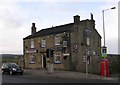
The Brown Cow - Thornton Road, Keelham
Image: © Betty Longbottom
Taken: 17 Nov 2007
0.05 miles
4
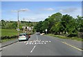
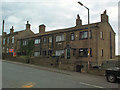
Keelham, Thornton
This is a revisit to the subject of the first geograph for the square: Image
Image: © Humphrey Bolton
Taken: 10 Jun 2021
0.06 miles
5
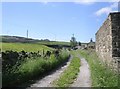
Footpath - Brighouse Road, Keelham
Image: © Betty Longbottom
Taken: 10 Jun 2008
0.07 miles
6
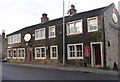
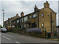
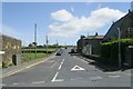
Keelham village
This row of houses is on the west side of the A644. The road leads to Queensbury (left) and Denholme (right).
Image: © David Spencer
Taken: 16 Aug 2005
0.07 miles
7
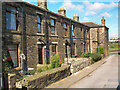
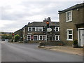
Keelham village
This is Keelham Place, tucked away off Well Heads.
Image: © David Spencer
Taken: 19 Aug 2005
0.09 miles
9
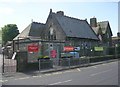
Keelham Primary School - Well Heads
Image: © Betty Longbottom
Taken: 10 Jun 2008
0.11 miles