IMAGES TAKEN NEAR TO
Foreside Lane, BRADFORD, BD13 4EY
Introduction
This page details the photographs taken nearby to Foreside Lane, BD13 4EY by members of the Geograph project.
The Geograph project started in 2005 with the aim of publishing, organising and preserving representative images for every square kilometre of Great Britain, Ireland and the Isle of Man.

There are currently over 7.5m images from over14,400 individuals and you can help contribute to the project by visiting https://www.geograph.org.uk
Image Map
Images are licensed for reuse under creativecommons.org/licenses/by-sa/2.0
Notes
- Clicking on the map will re-center to the selected point.
- The higher the marker number, the further away the image location is from the centre of the postcode.
Image Listing (19 Images Found)
Images are licensed for reuse under creativecommons.org/licenses/by-sa/2.0
Image
Details
Distance
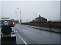
1
Foreside Lane and Denholme Velvets
Here is a mill still producing a textile product.
Image: © Humphrey Bolton
Taken: 26 Aug 2010
0.06 miles
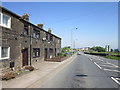
3
County Bridge, Denholme
Formerly workers cottages attached to Denholme Silk Weavers Mill. A landmark mill chimney once stood here.
Image: © Michael Fitzgerald
Taken: 26 Jun 2002
0.09 miles
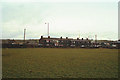
4
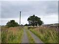
Foreside Bottom Lane
Approaching Fern Bank and Halifax Road
Image: © Kevin Waterhouse
Taken: 12 Aug 2024
0.10 miles
5
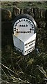
Old Milestone, on the A629, Denholme Gate,
N of traffic lights junction with B6145. Located on the West side of road, on verge next to LP 540 and 50 mph sign, opposite houses called County Bridge. Metal plate attached to stone post, WR casting design, erected by Keighley & Halifax turnpike trust, 19th century.
Inscription reads: HALIFAX / 5 MILES // DENHOLME / 1½ MILE / KEIGHLEY / (7 MILES) // KEIGHLEY & HALIFAX / ROAD / DENHOLME
Grade II listed by Historic England. see https://historicengland.org.uk/listing/the-list/list-entry/1314154
Milestone Society National ID: YW_KEHA07
Image: © Christine Minto
Taken: 31 Dec 2005
0.10 miles
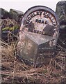
6
Old milestone
In 2011 this West Riding CC milestone was uprooted when the stone wall behind it was being rebuilt. It was reset about 2 metres from its original site on the A629 just north of the traffic light junction with the B6145. The distance to Halifax on the left-hand side is 5 MILES. There is a hole in the top of the stone which may be for an OS benchmark. it is Grade II listed 1133611.
Image: © Chris Minto
Taken: 17 Dec 2018
0.10 miles
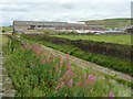
7
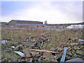
Former site of Denholme Velvets
The large mill which used to stand here has been demolished for a few years.
Image: © John Illingworth
Taken: 4 Dec 2015
0.10 miles
8
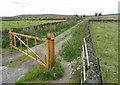
Foreside Lane, Denholme
A signpost indicates that it is a public right-of-way, but not what sort. The locked barrier is no doubt necessary to keep fly-tippers out.
Image: © Humphrey Bolton
Taken: 26 Aug 2010
0.12 miles
9
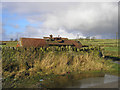
Tank
Some sort of water tank, rusting in a corner of a field on Foreside Lane.
Image: © John Illingworth
Taken: 29 Nov 2007
0.13 miles