IMAGES TAKEN NEAR TO
Main Road, BRADFORD, BD13 4DF
Introduction
This page details the photographs taken nearby to Main Road, BD13 4DF by members of the Geograph project.
The Geograph project started in 2005 with the aim of publishing, organising and preserving representative images for every square kilometre of Great Britain, Ireland and the Isle of Man.

There are currently over 7.5m images from over14,400 individuals and you can help contribute to the project by visiting https://www.geograph.org.uk
Image Map
Images are licensed for reuse under creativecommons.org/licenses/by-sa/2.0
Notes
- Clicking on the map will re-center to the selected point.
- The higher the marker number, the further away the image location is from the centre of the postcode.
Image Listing (99 Images Found)
Images are licensed for reuse under creativecommons.org/licenses/by-sa/2.0
Image
Details
Distance
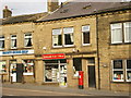
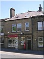
5
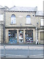
Unity House - Main Road
Former Co-op building.
Image: © Betty Longbottom
Taken: 18 Feb 2014
0.03 miles
8
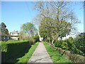
School Street, Denholme
This is the narrow part of the street that led to the former school, which has been replaced by houses. As it has no frontage properties (back gardens on the left, Foster Park on the right) it has been made into a footpath.
Image: © Humphrey Bolton
Taken: 24 Apr 2011
0.04 miles
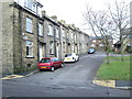
9
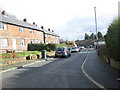
Minorca Mount - viewed from Mary Street
Image: © Betty Longbottom
Taken: 18 Feb 2014
0.04 miles