IMAGES TAKEN NEAR TO
Parkinson Road, BRADFORD, BD13 4BP
Introduction
This page details the photographs taken nearby to Parkinson Road, BD13 4BP by members of the Geograph project.
The Geograph project started in 2005 with the aim of publishing, organising and preserving representative images for every square kilometre of Great Britain, Ireland and the Isle of Man.

There are currently over 7.5m images from over14,400 individuals and you can help contribute to the project by visiting https://www.geograph.org.uk
Image Map
Images are licensed for reuse under creativecommons.org/licenses/by-sa/2.0
Notes
- Clicking on the map will re-center to the selected point.
- The higher the marker number, the further away the image location is from the centre of the postcode.
Image Listing (87 Images Found)
Images are licensed for reuse under creativecommons.org/licenses/by-sa/2.0
Image
Details
Distance
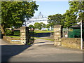
2
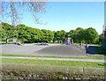
Skateboard area, Foster Park, Denholme
Now probably used more by young cyclists.
Image: © Humphrey Bolton
Taken: 24 Apr 2011
0.01 miles
3
Skateboard Park - Foster Park, Denholme
Image: © Betty Longbottom
Taken: 10 Jun 2008
0.01 miles
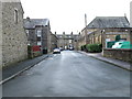

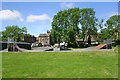
6

Foster Park - viewed from Parkinson Road
Image: © Betty Longbottom
Taken: 18 Feb 2014
0.04 miles

9
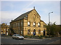
Denholme Library
Originally it was the Mechanics Institute
Image: © Alexander P Kapp
Taken: 2 Jun 2009
0.05 miles