IMAGES TAKEN NEAR TO
Foster Park View, BRADFORD, BD13 4BG
Introduction
This page details the photographs taken nearby to Foster Park View, BD13 4BG by members of the Geograph project.
The Geograph project started in 2005 with the aim of publishing, organising and preserving representative images for every square kilometre of Great Britain, Ireland and the Isle of Man.

There are currently over 7.5m images from over14,400 individuals and you can help contribute to the project by visiting https://www.geograph.org.uk
Image Map
Images are licensed for reuse under creativecommons.org/licenses/by-sa/2.0
Notes
- Clicking on the map will re-center to the selected point.
- The higher the marker number, the further away the image location is from the centre of the postcode.
Image Listing (79 Images Found)
Images are licensed for reuse under creativecommons.org/licenses/by-sa/2.0
Image
Details
Distance
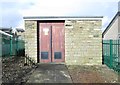
1
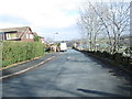
Foster Park View - viewed from nearby track
Image: © Betty Longbottom
Taken: 18 Feb 2014
0.02 miles
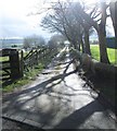
4
Lodge Gate Close - Foster Park Road
Image: © Betty Longbottom
Taken: 18 Feb 2014
0.04 miles
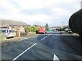
5
Electricity Substation No 1793 - Foster Park Road
Image: © Betty Longbottom
Taken: 18 Feb 2014
0.04 miles
8
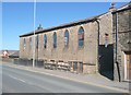
Former Wesleyan Sunday School, Denholme
Dated 1838, see Image There appears to have been dwellings in the basement.
Image: © Humphrey Bolton
Taken: 24 Apr 2011
0.09 miles
9
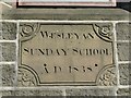
Datestone on the former Wesleyan Sunday School, Denholme
Image: © Humphrey Bolton
Taken: 24 Apr 2011
0.09 miles
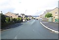
10
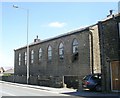
Wesleyan Sunday School - Main Road
Built 1838 - now in the process of conversion.
Image: © Betty Longbottom
Taken: 10 Jun 2008
0.09 miles