IMAGES TAKEN NEAR TO
Sowden Grange, BRADFORD, BD13 3TH
Introduction
This page details the photographs taken nearby to Sowden Grange, BD13 3TH by members of the Geograph project.
The Geograph project started in 2005 with the aim of publishing, organising and preserving representative images for every square kilometre of Great Britain, Ireland and the Isle of Man.

There are currently over 7.5m images from over14,400 individuals and you can help contribute to the project by visiting https://www.geograph.org.uk
Image Map (Loading...)


Getting Data...Please wait
Leaflet Map data © OpenStreetMap
Images are licensed for reuse under creativecommons.org/licenses/by-sa/2.0
Notes
- Clicking on the map will re-center to the selected point.
- The higher the marker number, the further away the image location is from the centre of the postcode.
Image Listing (152 Images Found)
Images are licensed for reuse under creativecommons.org/licenses/by-sa/2.0
Image
Details
Distance
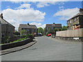
2
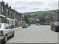
King Edward Terrace - looking towards King Edward Road
Image: © Betty Longbottom
Taken: 1 Jun 2013
0.03 miles
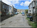
5
Windsor Grove - King Edward Terrace
Image: © Betty Longbottom
Taken: 1 Jun 2013
0.04 miles
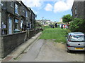
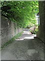
9
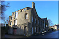
Former Wesleyan School on West Lane, Thornton
Now appears to be empty - the building is passed by the Bronte Way long distance footpath
Image: © Chris Heaton
Taken: 22 Dec 2016
0.05 miles
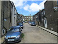
10
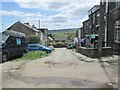
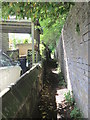
Cliffe Street - looking towards Reservoir View
Image: © Betty Longbottom
Taken: 1 Jun 2013
0.06 miles