IMAGES TAKEN NEAR TO
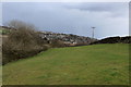
Alderscholes Lane, BRADFORD, BD13 3SY
Introduction
This page details the photographs taken nearby to Alderscholes Lane, BD13 3SY by members of the Geograph project.
The Geograph project started in 2005 with the aim of publishing, organising and preserving representative images for every square kilometre of Great Britain, Ireland and the Isle of Man.

There are currently over 7.5m images from over14,400 individuals and you can help contribute to the project by visiting https://www.geograph.org.uk
Image Map
Images are licensed for reuse under creativecommons.org/licenses/by-sa/2.0
Notes
- Clicking on the map will re-center to the selected point.
- The higher the marker number, the further away the image location is from the centre of the postcode.
Image Listing (29 Images Found)
Images are licensed for reuse under creativecommons.org/licenses/by-sa/2.0
Image
Details
Distance
1
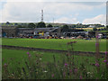
Alderscholes farm
Viewed from the Great Northern Trail.
Image: © Stephen Craven
Taken: 8 Aug 2015
0.01 miles
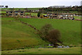
2
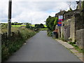
Alderscholes Lane at Green Clough
Looking south-westward.
Image: © Peter Wood
Taken: 5 Aug 2017
0.13 miles
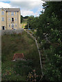
3
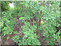
Overgrown railway bridge abutment
There would have been a bridge here carrying the railway over the footpath from Thornton Road to Alderscholes Lane. The present cycle route occupies only part of the width of the original trackbed, which at this point just west of Thornton station would have carried sidings as well as running lines.
Image: © Stephen Craven
Taken: 8 Aug 2015
0.14 miles
4
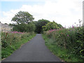
Start of the Great Northern Trail
A grand name for the 3km or so of former railway trackbed between Thornton and Queensbury, now part of National Cycle Network route 69.
Image: © Stephen Craven
Taken: 8 Aug 2015
0.15 miles
7
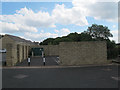
Septic tank, Rowlands Close, Thornton
This new estate Image is below the main road and therefore its sewer. The green cabinet presumably contains electrical equipment, so my guess is these are holding tanks from which sewage is intermittently pumped up to the main sewer.
Image: © Stephen Craven
Taken: 8 Aug 2015
0.16 miles
8
Steps down from Woodsley Fold
A section of the historic footpath from Thornton Road to Alderscholes Lane running through the new housing estate at Woodsley Fold has been equipped with steps.
Image: © Stephen Craven
Taken: 8 Aug 2015
0.17 miles
9
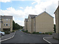
Woodsley Fold, off Thornton Road, Bradford (2)
Construction of this estate had started in or before 2008 Image and presumably stalled during the recession that started around that time. As of 2015 these houses were complete but others were still in construction.
Image: © Stephen Craven
Taken: 8 Aug 2015
0.18 miles
10
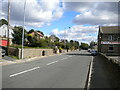
Thornton Road, Thornton
Looking towards the centre of the village from near the junction with Albion Place.
Image: © Richard Vince
Taken: 16 Sep 2022
0.18 miles