IMAGES TAKEN NEAR TO
Pit Lane, BRADFORD, BD13 3SU
Introduction
This page details the photographs taken nearby to Pit Lane, BD13 3SU by members of the Geograph project.
The Geograph project started in 2005 with the aim of publishing, organising and preserving representative images for every square kilometre of Great Britain, Ireland and the Isle of Man.

There are currently over 7.5m images from over14,400 individuals and you can help contribute to the project by visiting https://www.geograph.org.uk
Image Map (Loading...)


Getting Data...Please wait
Leaflet Map data © OpenStreetMap
Images are licensed for reuse under creativecommons.org/licenses/by-sa/2.0
Notes
- Clicking on the map will re-center to the selected point.
- The higher the marker number, the further away the image location is from the centre of the postcode.
Image Listing (5 Images Found)
Images are licensed for reuse under creativecommons.org/licenses/by-sa/2.0
Image
Details
Distance
1
Pit Lane, near Mountain
Wiggling up the hillside towards Mountain at the top of the hill. Looking southwards from the vicinity of New Royd Gate.
Image: © David Spencer
Taken: 19 Aug 2005
0.03 miles
2

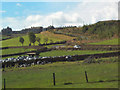
Hay Bales at Moor Royd Gate Farm
Country scene off Pit Lane
Image: © Chris Heaton
Taken: 21 Mar 2017
0.08 miles
3

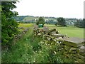
Nettle Hole Farm
As seen from Pit Lane
Image: © Chris Heaton
Taken: 21 Mar 2017
0.15 miles
4
Gill Lane, Thornton
This public footpath seen here from Malt Kiln Lane, goes past a golf course and down to Alderscholes Lane.
Image: © Humphrey Bolton
Taken: 24 Jun 2010
0.18 miles
