IMAGES TAKEN NEAR TO
Ewart Street, BRADFORD, BD13 2PP
Introduction
This page details the photographs taken nearby to Ewart Street, BD13 2PP by members of the Geograph project.
The Geograph project started in 2005 with the aim of publishing, organising and preserving representative images for every square kilometre of Great Britain, Ireland and the Isle of Man.

There are currently over 7.5m images from over14,400 individuals and you can help contribute to the project by visiting https://www.geograph.org.uk
Image Map
Images are licensed for reuse under creativecommons.org/licenses/by-sa/2.0
Notes
- Clicking on the map will re-center to the selected point.
- The higher the marker number, the further away the image location is from the centre of the postcode.
Image Listing (239 Images Found)
Images are licensed for reuse under creativecommons.org/licenses/by-sa/2.0
Image
Details
Distance
5
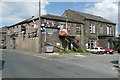
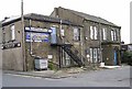
Queensbury Conservative Club, Chapel Street
Image: © Humphrey Bolton
Taken: 24 Jun 2010
0.02 miles
6
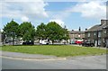
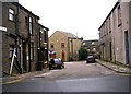
The green between Chapel Street and Albert Road, Queensbury
Image: © Humphrey Bolton
Taken: 24 Jun 2010
0.02 miles

8
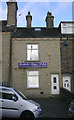
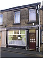
Bostock Boyce Welch (Accountants ) - High Street
Image: © Betty Longbottom
Taken: 2 Nov 2009
0.02 miles
9
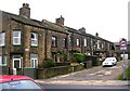
High Street Dental Practice - High Street
Image: © Betty Longbottom
Taken: 2 Nov 2009
0.03 miles
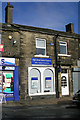
10
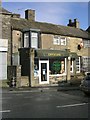
Victoria Gore Optician - High Street
Image: © Betty Longbottom
Taken: 2 Nov 2009
0.03 miles