IMAGES TAKEN NEAR TO
High Street, BRADFORD, BD13 2PD
Introduction
This page details the photographs taken nearby to High Street, BD13 2PD by members of the Geograph project.
The Geograph project started in 2005 with the aim of publishing, organising and preserving representative images for every square kilometre of Great Britain, Ireland and the Isle of Man.

There are currently over 7.5m images from over14,400 individuals and you can help contribute to the project by visiting https://www.geograph.org.uk
Image Map (Loading...)


Getting Data...Please wait
Leaflet Map data © OpenStreetMap
Images are licensed for reuse under creativecommons.org/licenses/by-sa/2.0
Notes
- Clicking on the map will re-center to the selected point.
- The higher the marker number, the further away the image location is from the centre of the postcode.
Image Listing (209 Images Found)
Images are licensed for reuse under creativecommons.org/licenses/by-sa/2.0
Image
Details
Distance
1
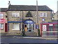
Charles Walker Surveyors & Estate Agents - Chapel Street
Image: © Betty Longbottom
Taken: 2 Nov 2009
0.01 miles
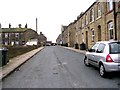
7
North John Street - Alexandra Street
Image: © Betty Longbottom
Taken: 27 Dec 2008
0.02 miles
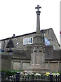
8
Albert Edward Street - Alexandra Street
Image: © Betty Longbottom
Taken: 27 Dec 2008
0.02 miles
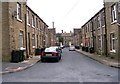
9
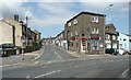
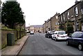
Junction of Chapel Street and High Street, Queensbury
High Street is the A647, and it is actually rather busy; I had to wait awhile to get a clear view. Chapel Street cuts across to the Keighley Road, A644.
Image: © Humphrey Bolton
Taken: 24 Jun 2010
0.02 miles
10
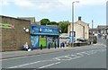
The Co-op, Chapel Street, Queensbury
Image: © Humphrey Bolton
Taken: 24 Jun 2010
0.02 miles