IMAGES TAKEN NEAR TO
Lewis Close, BRADFORD, BD13 2GF
Introduction
This page details the photographs taken nearby to Lewis Close, BD13 2GF by members of the Geograph project.
The Geograph project started in 2005 with the aim of publishing, organising and preserving representative images for every square kilometre of Great Britain, Ireland and the Isle of Man.

There are currently over 7.5m images from over14,400 individuals and you can help contribute to the project by visiting https://www.geograph.org.uk
Image Map (Loading...)


Getting Data...Please wait
Leaflet Map data © OpenStreetMap
Images are licensed for reuse under creativecommons.org/licenses/by-sa/2.0
Notes
- Clicking on the map will re-center to the selected point.
- The higher the marker number, the further away the image location is from the centre of the postcode.
Image Listing (182 Images Found)
Images are licensed for reuse under creativecommons.org/licenses/by-sa/2.0
Image
Details
Distance
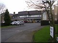
1
The Willows Medical Centre - Osbourne Drive
Image: © Betty Longbottom
Taken: 27 Dec 2008
0.02 miles
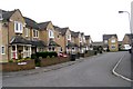
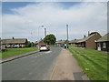
5
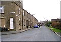
Queensbury House - Nelson Street
This is now occupied by Samson Bairstow & Sons, Funeral Directors.
Image: © Betty Longbottom
Taken: 17 Nov 2007
0.06 miles
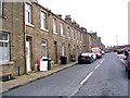
6
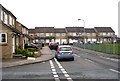
Ashbourne Crescent - looking towards New Park Road
Image: © Betty Longbottom
Taken: 19 Jun 2013
0.06 miles
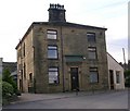
7
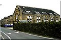
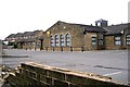
Baptist School - Chapel Lane
General Baptist School built 1823 - enlarged 1853 - now converted into apartments.
Image: © Betty Longbottom
Taken: 21 Aug 2007
0.06 miles